Montecito, California | |
|---|---|
|
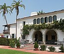
Clockwise: view of Montecito and the Pacific Ocean from the Santa Ynez Mountains; Our Lady of Mount Carmel Church; Lotusland; Butterfly Beach; Casa del Herrero | |
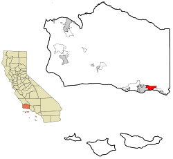
 Location in Santa Barbara County and the state of California | |
| Coordinates: 34°26′N 119°38′W / 34.433°N 119.633°W | |
| Country | United States |
| State | California |
| County | Santa Barbara |
| Government | |
| • State senator | Monique Limón (D)[1] |
| • Assembly Member | Gregg Hart (D)[1] |
| • U. S. rep. | Salud Carbajal (D)[2] |
| Area | |
| • Total | 9.265 sq mi (23.994 km2) |
| • Land | 9.259 sq mi (23.979 km2) |
| • Water | 0.006 sq mi (0.014 km2) 0.06% |
| Elevation | 180 ft (55 m) |
| Population | |
| • Total | 8,638 |
| • Density | 930/sq mi (360/km2) |
| Time zone | UTC−8 (Pacific) |
| • Summer (DST) | UTC−7 (PDT) |
| ZIP Codes | 93108, 93150 |
| Area code | 805 and 820 |
| FIPS code | 06-48844 |
| GNIS feature IDs | 1661052, 2408861 |
Montecito (archaic use of Spanish for woodland or countryside)[6] is an unincorporated town in Santa Barbara County, California, United States.[7][8][9] Located on the Central Coast of California, Montecito sits between the Santa Ynez Mountains and the Pacific Ocean. Montecito is best known as a celebrity enclave, owing to its concentration of prominent residents.[10] An affluent town, the median home price was $7.5 million in 2024.[11] For statistical purposes, the United States Census Bureau has defined Montecito as a census-designated place (CDP). The population as of 2022 is approximately 8,638 residents.
- ^ a b "Statewide Database". UC Regents. Archived from the original on February 1, 2015. Retrieved November 7, 2014.
- ^ "California's 24th Congressional District - Representatives & District Map". Civic Impulse, LLC. Retrieved September 29, 2014.
- ^ "2010 Census U.S. Gazetteer Files – Places – California". United States Census Bureau.
- ^ "Montecito". Geographic Names Information System. United States Geological Survey, United States Department of the Interior. Retrieved November 7, 2014.
- ^ "Montecito CDP, California Quickfacts". United States Census Bureau.
- ^ Cite error: The named reference
MJ 2021-08-12was invoked but never defined (see the help page). - ^ Panzar, Javier (December 12, 2017). "Ornamental landscaping in celebrity-studded Montecito adds to fire danger". LA Times. Retrieved December 13, 2017.
- ^ McCormack, Don (1999). McCormack's Guides Santa Barbara and Ventura 2000. Mccormacks Guides. p. 58. ISBN 9781929365098.
- ^ QuickFacts Montecito CDP, California Montecito CDP, California Population Estimates, July 1, 2022, (V2022)], U.S. Bureau of the Census.
- ^ Amy Larocca (July 30, 2023). "What Is It About Montecito?". New York Times.
- ^ Mauhay-Moore, Sam (2024). "Homeowners in wealthy Calif. town try to block public trail". SFGATE.


