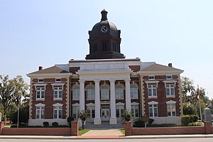
Montgomery County | |
|---|---|
 Montgomery County Courthouse (built 1907) in Mount Vernon | |
 Location within the U.S. state of Georgia | |
 Georgia's location within the U.S. | |
| Coordinates: 32°10′N 82°32′W / 32.17°N 82.53°W | |
| Country | |
| State | |
| Founded | December 19, 1793 |
| Named for | Richard Montgomery |
| Seat | Mount Vernon |
| Largest city | Mount Vernon |
| Area | |
| • Total | 245 sq mi (630 km2) |
| • Land | 240 sq mi (600 km2) |
| • Water | 5.2 sq mi (13 km2) 2.1% |
| Population (2020) | |
| • Total | 8,610 |
| • Density | 36/sq mi (14/km2) |
| Time zone | UTC−5 (Eastern) |
| • Summer (DST) | UTC−4 (EDT) |
| Congressional district | 12th |
| Website | montgomerycountyga |
Montgomery County is a county located in the central portion of the U.S. state of Georgia. As of the 2020 census, the population was 8,610.[1] The county seat is Mount Vernon.[2] Montgomery County is part of the Vidalia, GA micropolitan statistical area.
- ^ "Census - Geography Profile: Montgomery County, Georgia". United States Census Bureau. Retrieved December 27, 2022.
- ^ "Find a County". National Association of Counties. Retrieved June 7, 2011.