Monticello, Missouri | |
|---|---|
 Lewis County Courthouse, October 2014 | |
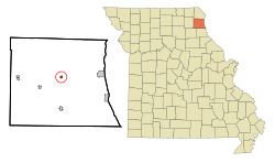
 Location of Monticello, Missouri | |
| Coordinates: 40°07′08″N 91°42′47″W / 40.11889°N 91.71306°W | |
| Country | United States |
| State | Missouri |
| County | Lewis |
| Area | |
| • Total | 0.26 sq mi (0.68 km2) |
| • Land | 0.26 sq mi (0.68 km2) |
| • Water | 0.00 sq mi (0.00 km2) |
| Elevation | 650 ft (200 m) |
| Population (2020) | |
| • Total | 104 |
| • Density | 398.47/sq mi (153.88/km2) |
| Time zone | UTC-6 (Central (CST)) |
| • Summer (DST) | UTC-5 (CDT) |
| ZIP code | 63457 |
| Area code | 573 |
| FIPS code | 29-49592[3] |
| GNIS feature ID | 2399389[2] |
Monticello is a rural village in, and county seat of, Lewis County, Missouri, United States, along the North Fabius River.[4] The population was 104 at the 2020 census,[5] and according to this census, Monticello is the county seat with the smallest population in the State of Missouri. The town is named in honor of President Thomas Jefferson's estate in Virginia.[6] Monticello is part of the Quincy, IL–MO Micropolitan Statistical Area.

- ^ "ArcGIS REST Services Directory". United States Census Bureau. Retrieved August 28, 2022.
- ^ a b U.S. Geological Survey Geographic Names Information System: Monticello, Missouri
- ^ "U.S. Census website". United States Census Bureau. Retrieved January 31, 2008.
- ^ "Find a County". National Association of Counties. Retrieved June 7, 2011.
- ^ "Explore Census Data". data.census.gov. Retrieved January 4, 2022.
- ^ Cite error: The named reference
NRHPwas invoked but never defined (see the help page).