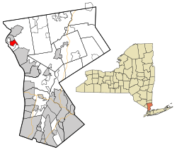
Montrose, New York | |
|---|---|
 Location of Montrose, New York | |
| Coordinates: 41°15′8″N 73°55′54″W / 41.25222°N 73.93167°W | |
| Country | United States |
| State | New York |
| County | Westchester |
| Town | Cortlandt |
| Area | |
| • Total | 2.46 sq mi (6.36 km2) |
| • Land | 1.62 sq mi (4.20 km2) |
| • Water | 0.84 sq mi (2.16 km2) |
| Elevation | 118 ft (36 m) |
| Population (2020) | |
| • Total | 2,862 |
| • Density | 1,766.67/sq mi (681.96/km2) |
| Time zone | UTC−5 (Eastern (EST)) |
| • Summer (DST) | UTC−4 (Eastern (EST)) |
| ZIP Code | 10548 |
| Area code | 914 |
| FIPS code | 36-48208 |
| GNIS feature ID | 0957565 |
Montrose is a hamlet (and census-designated place) within the town of Cortlandt, in the northwestern corner of Westchester County, New York, United States. The hamlet is named after the Montross family, most of whom worked nearby in Buchanan at the tannery.[2] It is located near Croton-on-Hudson and Buchanan. The once bucolic character of the hamlet has changed, but is still defined by the Hudson River, numerous wooded hills and steep slopes, wetland areas and streams, while increases in population have designated the area part of the New York--Jersey City--Newark NY--NJ urban area.[3] As of the 2020 census, Montrose had a population of 2,862.[4]
- ^ "ArcGIS REST Services Directory". United States Census Bureau. Retrieved September 20, 2022.
- ^ Ferris, Marc (May 2, 2024). "Montrose Proud: A Legacy Memorable and Venerable". River Journal Online - News for Tarrytown, Sleepy Hollow, Irvington, Ossining, Briarcliff Manor, Croton-on-Hudson, Cortlandt and Peekskill. Retrieved October 1, 2024.
- ^ Bureau, US Census. "2020 Census Urban Areas Wall Map". Census.gov. Retrieved October 1, 2024.
{{cite web}}:|last=has generic name (help) - ^ "Geographic Identifiers: 2010 Demographic Profile Data (G001): Montrose CDP, New York". U.S. Census Bureau, American Factfinder. Archived from the original on February 12, 2020. Retrieved January 30, 2013.