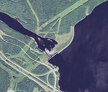
| Moore Dam | |
|---|---|
 Satellite view | |
| Country | United States |
| Location | New Hampshire and Vermont |
| Coordinates | 44°20′09″N 71°52′29″W / 44.33583°N 71.87472°W |
| Purpose | Hydroelectric |
| Construction began | 1954 |
| Opening date | 1956 |
| Owner(s) | TransCanada |
| Dam and spillways | |
| Type of dam | Embankment, gravity |
| Impounds | Connecticut River |
| Height (foundation) | 178 ft (54 m)[1] |
| Length | 2,920 ft (890 m)[1] |
| Spillway type | Gated overflow[1] |
| Reservoir | |
| Total capacity | 223,722 acre⋅ft (275,957,000 m3)[1] |
| Catchment area | 1,514 sq mi (3,920 km2)[2] |
| Surface area | 3,490 acres (1,410 ha)[1] |
| Normal elevation | 809 ft (247 m)[1] |
| Moore Station | |
| Type | Conventional |
| Hydraulic head | 150 ft (46 m)[1] |
| Turbines | 4x 56,400 HP Francis |
| Installed capacity | 140.4 MW (rated)[1] |
| Annual generation | 314,300,000 KWh (2009)[3] |
Moore Dam is a major hydroelectric dam on the Upper Connecticut River between Grafton County, New Hampshire and Caledonia County, Vermont in the northeastern United States. The dam is located near Littleton, New Hampshire, and forms the 3,490-acre (1,410 ha) Moore Reservoir. The Moore Station is the largest conventional hydroelectric plant in New England,[4] in terms of installed capacity and average power generation. The dam and reservoir also provide flood control, recreational boating and fishing.
The official name of the dam is the Samuel C. Moore Dam, after a former president of the now defunct New England Power Company that originally built it. The dam, reservoir and power station are now owned and operated by TransCanada Corporation.
- ^ a b c d e f g h "LIHI Certificate #39 | 15-Mile Falls | Low Impact Hydropower Institute". Lowimpacthydro.org. Archived from the original on April 3, 2017. Retrieved January 8, 2017.
- ^ Cite error: The named reference
USGSwas invoked but never defined (see the help page). - ^ Cite error: The named reference
carmawas invoked but never defined (see the help page). - ^ "Chapter 11 : Dams" (PDF). Des.nh.gov. Archived from the original (PDF) on December 28, 2016. Retrieved September 8, 2018.

