| Moose Jaw River | |
|---|---|
 Moose Jaw River | |
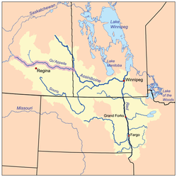
 The Red River drainage basin, with the Qu'Appelle River highlighted | |
| Location | |
| Country | Canada |
| Provinces | |
| Physical characteristics | |
| Source | Ibsen Lake |
| • coordinates | 49°47′0″N 104°15′22″W / 49.78333°N 104.25611°W |
| • elevation | 575 m (1,886 ft) |
| Mouth | Qu'Appelle River |
• location | Buffalo Pound Provincial Park |
• coordinates | 50°34′04″N 105°17′42″W / 50.5679°N 105.2949°W |
| Basin size | 9,360 km2 (3,610 sq mi) |
| Basin features | |
| River system | Red River drainage basin |
| Tributaries | |
| • left | |
Moose Jaw River[1] is a river in the Canadian province of Saskatchewan. It is located in the southern part of the province in a region called the Prairie Pothole Region of North America, which extends throughout three Canadian provinces and five U.S. states. It is also within Palliser's Triangle and the Great Plains ecoregion.[2]
The Moose Jaw River drainage basin is one of five sub-basins that make up the Upper Qu'Appelle Watershed.[3] Craven Dam at the village of Craven is the dividing point between the upper and lower watersheds of the Qu'Appelle River. The river and its tributaries drain a total of 9,360 square kilometres (3,610 sq mi).[4] The total combined drainage area for the five sub-basins of the Upper Qu'Appelle Watershed is 23,443 square kilometres (9,051 sq mi).[5] The Qu'Appelle River system is part of the much larger Hudson Bay drainage basin.
- ^ "Moose Jaw River". Canadian Geographical Names Database. Government of Canada. Retrieved 30 November 2022.
- ^ Bonikowsky, Laura (14 July 2013). "Drought in Palliser's Triangle". The Canadian Encyclopedia. Retrieved 12 March 2024.
- ^ "Our Watershed". WUQWATR. Retrieved 19 September 2021.
- ^ Caring for Our Watersheds. (n.d.). Watershed information. Retrieved from https://caringforourwatersheds.com/canada/saskatchewan/watershed-information/
- ^ "Our Watershed". WUQWATR. Retrieved 17 September 2021.

