Mori
森町 | |
|---|---|
Town | |
 Mori Station with Mount Komagatake in the background | |
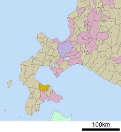
 The location of Mori in Oshima Subprefecture. | |
| Coordinates: 42°6′N 140°35′E / 42.100°N 140.583°E | |
| Country | Japan |
| Prefecture | Hokkaido |
| Subprefecture | Oshima Subprefecture |
| District | Kayabe |
| Government | |
| • Mayor | Keizō Kajiya |
| Area | |
| • Total | 368.27 km2 (142.19 sq mi) |
| Population (2016-09-30) | |
| • Total | 16,299 |
| • Density | 44/km2 (110/sq mi) |
| Post code | 049-2393 |
| Area code | 01374 |
| Government Office Address | Banchi 1, Aza Gokōmachi 144, Mori-machi, Kayabe-gun, Hokkaidō 049-2393 |
| Government Office Telephone | 01374-2-2181 |
| Community Identification Number | 01345-5 |
| Climate | Dfb |
| Website | http://www.town.hokkaido-mori.lg.jp/ |
| Symbols | |
| Bird | Common gull |
| Flower | Cherry blossom |
| Tree | Chestnut |
Mori (森町, Mori-machi) is a town located in Oshima Subprefecture, Hokkaido, Japan.
The total area of the town is 368.27 square kilometres (142.19 sq mi). As of September 2016, the town had a population of 16,299, and a population density of 44 persons per km2.[1][2]
Mount Komagatake, an active volcano, is located to the east of Mori, and much of the town is part of Ōnuma Quasi-National Park.[3] Mori is the home of ikameshi, a squid and rice dish invented in the mid-20th century.[4]
- ^ 森町 [Town of Mori] (in Japanese). Mori, Hokkaido: Town of Mori. 2012. Retrieved Oct 10, 2012.
- ^ "森(町)" [Mori]. Nihon Daihyakka Zensho (Nipponika) (in Japanese). Tokyo: Shogakukan. 2012. OCLC 153301537. Archived from the original on 2007-08-25. Retrieved 2012-10-09.
- ^ Cite error: The named reference
onumawas invoked but never defined (see the help page). - ^ いかめし [Ikameshi] (in Japanese). Mori, Hokkaido, Japan: Ikameshi Abeshoten Co. 2002. Retrieved Dec 6, 2012.


