Morongo Valley, California | |
|---|---|
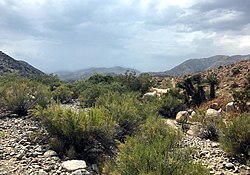
 Little Morongo Canyon, Morongo Valley, California | |
 Location in San Bernardino County and the state of California | |
| Coordinates: 34°02′49″N 116°34′51″W / 34.04694°N 116.58083°W[1] | |
| Country | United States |
| State | California |
| County | San Bernardino |
| Area | |
| • Total | 25.219 sq mi (65.317 km2) |
| • Land | 25.219 sq mi (65.317 km2) |
| • Water | 0 sq mi (0 km2) 0% |
| Elevation | 2,582 ft (787 m) |
| Population | |
| • Total | 3,514 |
| • Density | 140/sq mi (54/km2) |
| Time zone | UTC-8 (PST) |
| • Summer (DST) | UTC-7 (PDT) |
| ZIP code | 92256 |
| Area codes | 442/760 |
| FIPS code | 06-49348 |
| GNIS feature ID | 1652755 |
Morongo Valley is a census-designated place (CDP) on State Route 62 in San Bernardino County, California, United States. The population was 3,552 at the 2010 census, up from 1,929 at the 2000 census. The town is bordered by Yucca Valley, California.

- ^ a b "Morongo Valley". Geographic Names Information System. United States Geological Survey, United States Department of the Interior. Retrieved November 18, 2014.
- ^ "2010 Census U.S. Gazetteer Files – Places – California". United States Census Bureau.
- ^ "US Census Bureau". www.census.gov. Retrieved September 8, 2024.
