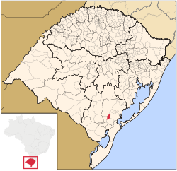
Morro Redondo | |
|---|---|
 Location within Rio Grande do Sul | |
| Coordinates: 31°35′18″S 52°37′55″W / 31.58833°S 52.63194°W | |
| Country | |
| State | Rio Grande do Sul |
| Mesoregion | Sudeste Rio-Grandense |
| Microregion | Pelotas |
| Founded | May 12, 1988 |
| Area | |
| • Total | 244.65 km2 (94.46 sq mi) |
| Elevation | 245 m (804 ft) |
| Population (2020 [1]) | |
| • Total | 6,589 |
| • Density | 27/km2 (70/sq mi) |
| Time zone | UTC−3 (BRT) |
| IBGE code | 4312450 |
| Website | morroredondo.rs.gov.br |
Morro Redondo (English: Rounded Hill) is a Brazilian municipality in the southern part of the state of Rio Grande do Sul. The population is 6,589 (2020 est.) in an area of 244.65 km².[2] It is located 35 km (21.75 mi) from Pelotas.


