This article includes a list of general references, but it lacks sufficient corresponding inline citations. (July 2018) |
Moss Park | |
|---|---|
Neighbourhood | |
 In the 1960s, many buildings were demolished to make way for large public housing towers | |
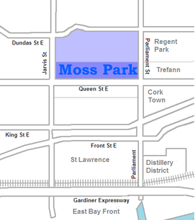
 The Moss Park towers all lie south of Shuter St, but the area north to Dundas is also sometimes considered part of the neighbourhood | |
| Coordinates: 43°39′21″N 79°22′02″W / 43.655709°N 79.367316°W | |
| Country | |
| Province | |
| City | Toronto |
Moss Park is a residential neighbourhood located in downtown Toronto, Ontario, Canada.[1] The area known as Moss Park is typically considered to be between Jarvis Street and Parliament Street, south of Dundas Street, an area dominated by public housing projects. According to one set of boundaries of the City of Toronto, it is roughly L-shaped, bounded on the north by Carlton Street to Parliament Street, on the east by Parliament Street to Queen Street East and the Don River, on the south by Eastern Avenue and Front Street, and on the west by Jarvis Street. This larger concept of the area includes the neighbourhoods known as Corktown and the Garden District, as well as a portion of Cabbagetown.
- ^ Louis-McBurnie, Keisha St; Pagaling, Nikki Mary; Roberts, David J. (2021). "The work of crisis framing: Claims of social justice obscuring a history and, likely future, of uneven investment in Moss Park, Toronto". Journal of Urban Affairs. doi:10.1080/07352166.2020.1863816. ISSN 0735-2166.
