| Mossman Gorge Queensland | |||||||||||||||
|---|---|---|---|---|---|---|---|---|---|---|---|---|---|---|---|
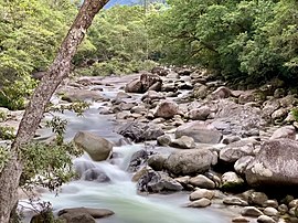
 Mossman River in the Mossman Gorge | |||||||||||||||
| Coordinates | 16°28′03″S 145°21′07″E / 16.4675°S 145.3519°E | ||||||||||||||
| Population | 248 (2021 census)[1] | ||||||||||||||
| • Density | 37.0/km2 (95.9/sq mi) | ||||||||||||||
| Postcode(s) | 4873 | ||||||||||||||
| Area | 6.7 km2 (2.6 sq mi) | ||||||||||||||
| Time zone | AEST (UTC+10:00) | ||||||||||||||
| Location | |||||||||||||||
| LGA(s) | Shire of Douglas | ||||||||||||||
| State electorate(s) | Cook | ||||||||||||||
| Federal division(s) | Leichhardt | ||||||||||||||
| |||||||||||||||

Mossman Gorge is a rural locality in the Shire of Douglas, Queensland, Australia.[2] In the 2021 census, Mossman Gorge had a population of 248 people.[1]
The locality takes its name from the valley Mossman Gorge created by the Mossman River through the Daintree National Park to the west of the locality (in Syndicate and Shannonvale). The Mossman Gorge Centre is the gateway to the valley which is a tourist attraction with a suspension bridge providing access to a 2.4-kilometre (1.5 mi) loop walk through the rainforest of the National Park. It is part of the traditional homeland of the indigenous Kuku Yalanji people (Goo-goo Ya-lan-gee).[3][4][5][6]
- ^ a b Cite error: The named reference
Census2021was invoked but never defined (see the help page). - ^ "Mossman Gorge – locality in Shire of Douglas (entry 48777)". Queensland Place Names. Queensland Government. Retrieved 4 November 2019.
- ^ Cite error: The named reference
Culture-People-Historywas invoked but never defined (see the help page). - ^ Cite error: The named reference
Bamanga-Bubu-Ngadimunku-1996was invoked but never defined (see the help page). - ^ Cite error: The named reference
Bamanga-Bubu-Ngadimunku-2008was invoked but never defined (see the help page). - ^ Cite error: The named reference
Nature-Culture-Historywas invoked but never defined (see the help page).
