Māori: Te Motu-a-Ihenga | |
|---|---|
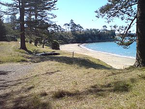
 The beach on the northern side of the narrow western neck, separated from the southern beach by about 30 m (33 yd) | |
 Location of Motuihe Island in the Hauraki Gulf | |
| Geography | |
| Coordinates | 36°48′37″S 174°56′49″E / 36.810212°S 174.947019°E |
| Area | 179 ha (440 acres) |
| Administration | |
| Demographics | |
| Population | 1 |

Motuihe Island (official name: Motuihe Island / Te Motu-a-Ihenga)[1] lies between Motutapu and Waiheke islands in the Hauraki Gulf of New Zealand, near Auckland. The island measures 179 ha (440 acres),[2] of which around 18 ha (44 acres) are remnants of coastal forest. The island is a recreation reserve controlled by the Department of Conservation (DOC) and administered by the Motuihe Trust. It is a popular spot for day trips, accessible from Auckland by seaplane or by private boat. The island is known for its beautiful beaches.[3][4]
The name comes from Te Motu-a-Ihenga, Māori for 'Ihenga's Island'.[5]
- ^ "New Zealand Gazetteer". Land Information New Zealand. Retrieved 18 November 2022.
- ^ "Data Table - Protected Areas - LINZ Data Service (recorded area 178.6433 ha)". Land Information New Zealand. Retrieved 3 September 2019.
- ^ "Motuihe Recreation Reserve". Department of Conservation. Retrieved 27 February 2008.
- ^ "Motuihe Project Archived 14 October 2008 at the Wayback Machine". Motuihe Trust. Retrieved 27 February 2008.
- ^ "Motuihe Recreation Reserve: History". Department of Conservation. Retrieved 27 February 2008.