| Mount Aragats | |
|---|---|
 | |
| Highest point | |
| Elevation | 4,090 m (13,420 ft)[1][2] |
| Prominence | 2,143 m (7,031 ft)[3] |
| Isolation | 88.62 km (55.07 mi) |
| Listing | |
| Coordinates | 40°32′00″N 44°12′00″E / 40.53333°N 44.20000°E |
| Geography | |
| Country | Armenia |
| Provinces | |
| Towns/villages | |
| Parent range | Lesser Caucasus Armenian Highlands |
| Geology | |
| Rock age | Holocene[1] |
| Mountain type | Stratovolcano |
| Last eruption | Unknown[1] |
| Climbing | |
| First ascent | July 1843 Khachatur Abovian and Moritz Wagner[4] |
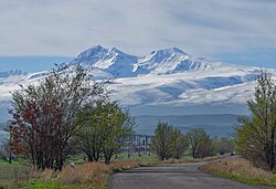
Mount Aragats (Armenian: Արագած, pronounced [ɑɾɑˈɡɑt͡s]) is an isolated four-peaked volcano massif in Armenia. Its northern summit, at 4,090 m (13,420 ft) above sea level, is the highest point of the Lesser Caucasus and Armenia. It is also one of the highest points in the Armenian Highlands.[a]
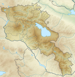
The Aragats massif is surrounded by the Kasagh River on the east, the Akhurian River on the west, Ararat Plain on the south, and Shirak Plain on the north.[2] The circumference of the massif is around 200 km (120 mi),[10][9] and covers an area of 6,000 km2 (2,300 sq mi)[11] or around 1⁄5 of Armenia's total area.[b] 944 km2 (364 sq mi) of the massif is located above 2,000 m (6,600 ft).[13]
- ^ a b c Cite error: The named reference
gvpwas invoked but never defined (see the help page). - ^ a b Cite error: The named reference
cadastrewas invoked but never defined (see the help page). - ^ "High prominence mountains in Caucasus and Russia outside of Europe". ii.uib.no. Institutt for informatikk University of Bergen.
- ^ Ketchian, Philip K. (December 24, 2005). "Climbing Ararat: Then and Now". The Armenian Weekly. 71 (52). Archived from the original on September 8, 2009.
- ^ Cite error: The named reference
armgeowas invoked but never defined (see the help page). - ^ Aslani︠a︡n, A. T. (1973). "Yerevan-Southern Summit of Aragats Volcano". Guide-book of Excursions of the All-union Conference for the Study of the Quaternary Period: Armenian SSR. Academy of Sciences of the Armenian SSR Institute of Geological Sciences. p. 72.
By its height among the highest peaks of the Armenian highland Aragats gives way only to Ararat — the famous biblical mountain that rises for more than 1 km.
- ^ Hewsen, Robert H.; Anania Shirakatsi (1992). The Geography of Ananias of Širak: Ašxarhacʻoycʻ, the Long and the Short Recensions. Reichert. p. 217. ISBN 9783882264852.
The highest peak in the Armenian SSR, Aragac is the third highest mountain on the Armenian plateau after Ararat (16,916 ft. /5172 m), and Sip'an (Subhan, 14,543/4434).
- ^ Smith, Adam T. (2009). "Regional Investigations in the Tsaghkahovit Plain: Orientation and Methodology". The Foundations of Research and Regional Survey in the Tsaghkahovit Plain, Armenia. Oriental Institute of the University of Chicago. p. 95. ISBN 9781885923622.
Aragats is the third highest peak in the Armenian Highland after Great Ararat (5,165 m a.s.l.) and Süphan Dağı (4,434 m a.s.l.).
- ^ a b Cite error: The named reference
Nazarianwas invoked but never defined (see the help page). - ^ Adalian 2010, p. 3.
- ^ Cite error: The named reference
encyclopedia.amwas invoked but never defined (see the help page). - ^ "Armenia". The World Factbook. Central Intelligence Agency.
- ^ Martirosyan 2013, p. 127.
Cite error: There are <ref group=lower-alpha> tags or {{efn}} templates on this page, but the references will not show without a {{reflist|group=lower-alpha}} template or {{notelist}} template (see the help page).
