This article includes a list of general references, but it lacks sufficient corresponding inline citations. (September 2009) |
| Mount Arapiles (Djurid) | |
|---|---|
 | |
| Highest point | |
| Elevation | 370 metres (1,210 ft) AHD |
| Prominence | ~140 metres (460 ft) AHD |
| Coordinates | 36°45′3″S 141°49′58″E / 36.75083°S 141.83278°E |
| Geography | |
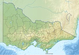
Location in Victoria | |
| Location | Wimmera region, Victoria, Australia |
| Geology | |
| Mountain type | metamorphic sandstone (quartzite) |
| Climbing | |
| First ascent | the first recorded ascent by a European 23 July 1836 by Thomas Mitchell |
| Easiest route | Hike/drive |
Mount Arapiles is a rock formation that rises about 140 metres (460 ft) above the Wimmera plains in western Victoria, Australia. It is located in Arapiles approximately 10 kilometres (6.2 mi) west of the town of Natimuk and is part of the Mount Arapiles-Tooan State Park. Arapiles is a very popular destination for rock climbers due to the quantity and quality of climbs. It is one of the premier climbing sites in Australia along with the nearby Grampians. The Wotjobaluk name for the formation is Djurid.[1]
- ^ Ian Clark, 'Multiple Aboriginal placenames in western and central Victoria', in Laura Kostanski and Luise Hercus (eds), Indigenous and Minority Placenames: Australian and International Perspectives (ANU Press, 2014) 239, 240 <https://www.researchgate.net/profile/Ian_Clark19/publication/322413717_Multiple_Aboriginal_placenames_in_western_and_central_Victoria/links/5a8f5e3eaca27214056017da/Multiple-Aboriginal-placenames-in-western-and-central-Victoria.pdf>
