Borough of Mount Carmel | |
|---|---|
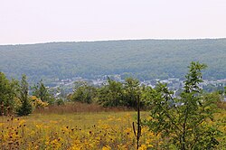
 View of Mount Carmel from the northeast | |
 Location of Mount Carmel in Northumberland County, Pennsylvania. | |
| Coordinates: 40°47′47″N 76°24′44″W / 40.79639°N 76.41222°W | |
| Country | United States |
| State | Pennsylvania |
| County | Northumberland |
| Settled | 1770 |
| Incorporated, Township | November 14, 1854 |
| Incorporated, Borough | November 3, 1862 |
| Government | |
| • Mayor | Phillip "Bing" Cimino (D) |
| • Chief of Police | Christopher J. Buhay |
| Area | |
| • Total | 0.66 sq mi (1.71 km2) |
| • Land | 0.66 sq mi (1.71 km2) |
| • Water | 0.00 sq mi (0.00 km2) |
| Elevation [2] (center of borough) | 1,100 ft (300 m) |
| Highest elevation [2] (southeastern boundary of borough) | 1,300 ft (400 m) |
| Lowest elevation [2] (Shamokin Creek on western borough boundary) | 1,035 ft (315 m) |
| Population | |
| • Total | 5,725 |
| • Density | 8,648.04/sq mi (3,341.16/km2) |
| Time zone | UTC-5 (EST) |
| • Summer (DST) | UTC-4 (EDT) |
| ZIP code | 17851 |
| Area codes | 570 and 272 |
| FIPS code | 42-51496 |
| FIPS | 51496 |
| Website | www |
Mount Carmel is a borough in Northumberland County, located in the Coal Heritage Region of Central Pennsylvania's Susquehanna River Valley, United States. The population was 5,725 at the 2020 census. It is located 88 miles (141 km) northwest of Philadelphia and 71 miles (114 km) northeast of Harrisburg, in the Coal Region. It is completely encircled by Mount Carmel Township.
- ^ "ArcGIS REST Services Directory". United States Census Bureau. Retrieved October 12, 2022.
- ^ a b c "Green Ridge Topo Map, Northumberland County PA (Mount Carmel Area)". TopoZone. Locality, LLC. Retrieved 28 November 2019.
- ^ Cite error: The named reference
USCensusDecennial2020CenPopScriptOnlywas invoked but never defined (see the help page).


