| Mountain Elgon | |
|---|---|
| Wagagai (summit) | |
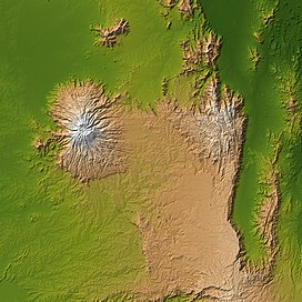
 Mount Elgon (left) and Great Rift Valley (right) | |
| Highest point | |
| Elevation | 4,321 m (14,177 ft)[1] Ranked 17th in Africa |
| Prominence | 2,458 m (8,064 ft)[1] |
| Isolation | 339 km (211 mi)[2] |
| Listing | Ultra |
| Coordinates | 01°07′06″N 34°31′30″E / 1.11833°N 34.52500°E[1] |
| Geography | |
| Topo map(s) | Mount Elgon Map and Guide[3] |
| Geology | |
| Rock age | Miocene origin |
| Mountain type | Shield volcano |
| Last eruption | Unknown |
| Climbing | |
| First ascent | 1911 by Kmunke and Stigler |
| Easiest route | Scramble |
Mount Elgon is an extinct shield volcano on the border of Uganda and Kenya,[4] north of Kisumu and west of Kitale. The mountain's highest point, named "Wagagai", is located entirely within Uganda.[1][5] Although there is no verifiable evidence of its earliest volcanic activity, geologists estimate that Mount Elgon is at least 24 million years old, making it the oldest extinct volcano in East Africa.[6] The mountain's name originates from its Maasai name, “Ol Doinyo Ilgoon” (Breast Mountain).[7]
- ^ a b c d Africa Ultra-Prominences Peaklist.org. Retrieved 2012-01-11.
- ^ [1] peakbagger.com, retrieved 19 March 2017
- ^ Mount Elgon Map and Guide (Map) (1st ed.). 1:50,000 with mountaineering information. EWP. 1989. ISBN 0-906227-46-1.
- ^ "Uganda Wildlife Authority". www.uwa.or.ug. Archived from the original on 2007-12-24. Retrieved 2008-03-16.
- ^ "Mount Elgon, Uganda" Peakbagger.com. Retrieved 11 January 2012
- ^ NASA (28 August 2005). "SRTM Africa Images". NASA. Retrieved 24 October 2015.
- ^ "Mount Elgon | volcano, Africa | Britannica". www.britannica.com. Retrieved 2024-02-19.


