| Mount Franklin (Willambeparamal) | |
|---|---|
 View from Highway | |
| Highest point | |
| Elevation | 648 metres (2,126 ft)[1] |
| Prominence | 270 m (890 ft)[2] |
| Coordinates | 37°15′54″S 144°09′02″E / 37.26509°S 144.15043°E |
| Geography | |
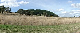
Mount Franklin (Djadjawurrung: Willambeparamal) is an extinct volcano about 10 km north of Daylesford and 4.6 km south east of Franklinford in Victoria, Australia.[1] A road spirals round the outside slopes covered with pine trees, into a flat 50 acre caldera, and onto the rim which hosts a fire lookout, parking area and picnic ground.
The flat summit area is now used as a free camping ground. A central lawn area is surrounded by a ring of campsites, with picnic tables and wood fire barbecues. There is space for tents, and to park caravans and RVs. A toilet block and water tank (non-potable) is located close to the entrance.
Being a prominent local landmark within Hepburn Shire, the mountain is included within the boundaries of the Mount Franklin Reserve[3] managed by Parks Victoria.
- ^ a b "Heritage story - Mount Franklin Hepburn Regional Park" (PDF). Parks Victoria. Archived from the original (PDF) on 2012-04-27. Retrieved 2012-04-16.
- ^ "Area around Mount Franklin". Bonzle Maps of Australia. Retrieved 2012-04-24.
- ^ "Mt Franklin Reserve". Parks Victoria. Retrieved 2012-04-16.
