| Mount Greylock | |
|---|---|
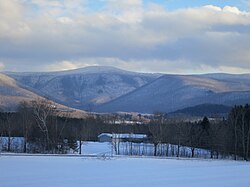
 Mt. Greylock seen from the West | |
| Highest point | |
| Elevation | 3,489 ft (1,063 m) NAVD 88[1] |
| Prominence | 2,463 ft (751 m)[2] |
| Listing | U.S. state high point 31st New England Fifty Finest 17th |
| Coordinates | 42°38′14″N 73°09′58″W / 42.63726°N 73.16599°W[1] |
| Geography | |
| Parent range | Taconic Mountains[3][4][5] |
| Geology | |
| Rock age(s) | Ordovician, Taconic orogeny |
| Mountain type | thrust fault |
| Climbing | |
| Easiest route | Cheshire Harbor Trail[6] |
Mount Greylock Summit Historic District | |
| Location | Jct. of Notch, Rockwell, and Summit Rds., Adams, Massachusetts |
|---|---|
| Area | 1,200 acres (490 ha)[8] |
| Built | 1830 |
| Architect | Maginnis and Walsh; Vance, Joseph MacArthur, et al. |
| Architectural style | Bungalow/Craftsman, Classical Revival |
| NRHP reference No. | 98000349[7] |
| Added to NRHP | April 20, 1998 |
Mount Greylock is the highest point in Massachusetts at 3,489 feet (1,063 meters). Located in northwest region of the state, it is part of the Taconic Mountains, a geologically distinct range from the nearby Berkshires and Green Mountains. Expansive views and a small area of sub-alpine forest characterize its upper reaches. A seasonal automobile road crosses the summit area near three structures from the 1930s, which together constitute a small National Historic District. Various hiking paths including the Appalachian Trail traverse the area, which is part of the larger Mount Greylock State Reservation.[9]
The peak played a role in 19th century American literature,[10][11][12] and is featured in the work of Nathaniel Hawthorne, Herman Melville, and Henry David Thoreau.
- ^ a b "Greylock RM 1 Reset". NGS Data Sheet. National Geodetic Survey, National Oceanic and Atmospheric Administration, United States Department of Commerce.
- ^ "Mount Greylock, Massachusetts". Peakbagger.com.
- ^ Day Hiker's Guide to Vermont 5th ed. (2006). Green Mountain Club: Waterbury Center, Vermont
- ^ Raymo, Chet and Raymo, Maureen E. (1989). Written in Stone: A Geologic History of the Northeastern United States. Chester, Connecticut: Globe Pequot.
- ^ Doll, Charles G. Centennial Geologic Map of Vermont (1961). United States Geological Survey: Washington
- ^ "Suggested Day Hikes" (PDF). MassParks: Mount Greylock State Reservation. Executive Office of Energy and Environmental Affairs, Department of Conservation and Recreation. September 2011. Retrieved July 20, 2013.
- ^ "National Register Information System". National Register of Historic Places. National Park Service. March 13, 2009.
- ^ "Massachusetts, Berkshire County Historic Districts". National Register of Historic Places. American Dreams Inc. Retrieved January 6, 2011.
- ^ Cite error: The named reference
dcrwas invoked but never defined (see the help page). - ^ Shannon O’Brien. "Ilvermorny on Greylock". Today. Williams College, MA. Retrieved January 11, 2024.
- ^ Wetherell, W. D. (June 7, 1998). "Where Melville Paid Homage to a Mountain". The New York Times. ISSN 0362-4331. Retrieved January 11, 2024.
- ^ "How Western Massachusetts' Mount Greylock Became Inspiration For Literary Legends". www.wbur.org. November 17, 2016. Retrieved January 11, 2024.
