Mount Hagen
The Heart of the Highlands | |
|---|---|
Town | |
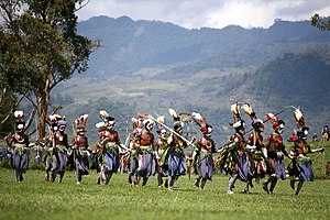
 Mt Hagen Cultural Show, one of the largest annual cultural events in Papua New Guinea | |
 Satellite view | |
| Coordinates: 5°51′36″S 144°14′24″E / 5.86000°S 144.24000°E | |
| Country | |
| Province | Western Highlands Province |
| District | Mount Hagen District |
| Established | 1934 |
| Elevation | 1,677 m (5,502 ft) |
| Population (2013) | |
| • Total | 46,256 |
| Time zone | UTC+10 (AEST) |
| Main languages | Melpa, Tok Pisin, English |
| Climate | Cfb |
Mount Hagen (Tok Pisin: Maun Hagen) is the third largest city in Papua New Guinea, with a population of 46,250. It is the capital of the Western Highlands Province and is located in the large fertile Wahgi Valley in central mainland Papua New Guinea, at an elevation of 1,677 m (5,502 ft).
The Highlands Highway is the main arterial route to connect Mount Hagen with the coastal cities of Lae and Madang.
The city is named after the old eroded volcano Mount Hagen, located about 24 kilometres (15 mi) to the north-west. The volcano was named after the German colonial officer Curt von Hagen (1859–1897).
