Mount Jackson, Virginia | |
|---|---|
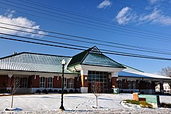
 Mount Jackson Town Hall, Visitor Center, Museum and Library in December 2013 | |
 Location of Mount Jackson, Virginia | |
| Coordinates: 38°45′00″N 78°38′15″W / 38.75000°N 78.63750°W | |
| Country | United States |
| State | Virginia |
| County | Shenandoah |
| Area | |
| • Total | 3.84 sq mi (9.93 km2) |
| • Land | 3.81 sq mi (9.87 km2) |
| • Water | 0.03 sq mi (0.07 km2) |
| Elevation | 909 ft (277 m) |
| Population (2010) | |
| • Total | 1,994 |
| • Estimate (2019)[2] | 2,118 |
| • Density | 555.91/sq mi (214.65/km2) |
| Time zone | UTC-5 (Eastern (EST)) |
| • Summer (DST) | UTC-4 (EDT) |
| ZIP code | 22842 |
| Area code | 540 |
| FIPS code | 51-53992[3] |
| GNIS feature ID | 1498404[4] |
| Website | Official website |
Mount Jackson is a town in Shenandoah County, Virginia, United States. The population was 1,994 at the 2010 census.
For highway travelers passing by, Mount Jackson is easily identified from I-81 exit 273 by the water tower painted as a basket of apples, which was recently repainted. For those exploring off the highway, the town has history as a commercial and railroad hub in the region, with rich Civil War heritage and a historic district listed on the National Register of Historic Places.
- ^ "2019 U.S. Gazetteer Files". United States Census Bureau. Retrieved August 7, 2020.
- ^ Cite error: The named reference
USCensusEst2019CenPopScriptOnlyDirtyFixDoNotUsewas invoked but never defined (see the help page). - ^ "U.S. Census website". United States Census Bureau. Retrieved January 31, 2008.
- ^ "US Board on Geographic Names". United States Geological Survey. October 25, 2007. Retrieved January 31, 2008.

