| Mount Kembla Wollongong, New South Wales | |||||||||||||||
|---|---|---|---|---|---|---|---|---|---|---|---|---|---|---|---|
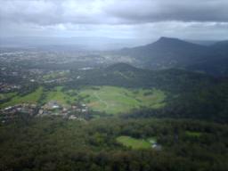
 The suburb of Mount Kembla viewed from Mount Keira | |||||||||||||||
| Coordinates | 34°25′43″S 150°49′28″E / 34.42861°S 150.82444°E | ||||||||||||||
| Population | 1,083 (2021 census)[1] | ||||||||||||||
| • Density | 677/km2 (1,750/sq mi) | ||||||||||||||
| Postcode(s) | 2526 | ||||||||||||||
| Elevation | 534 m (1,752 ft) | ||||||||||||||
| Area | 1.6 km2 (0.6 sq mi) | ||||||||||||||
| LGA(s) | City of Wollongong | ||||||||||||||
| State electorate(s) | Wollongong | ||||||||||||||
| Federal division(s) | Cunningham | ||||||||||||||
| |||||||||||||||
| Mount Kembla | |
|---|---|
| Hat Hill | |
 View of Mount Kembla from Mount Nebo | |
| Highest point | |
| Elevation | 534 m (1,752 ft)[2] |
| Coordinates | 34°26′30″S 150°48′30″E / 34.44167°S 150.80833°E[3] |
| Geography | |
Location in New South Wales | |
| Location | Illawarra region, New South Wales, Australia |
Mount Kembla /ˈkɛmblə/ is a suburb[4] and a mountain[3] in the Illawarra region of New South Wales, Australia.
The suburb, a semi-rural township of Wollongong, gets its name from the mountain, located on the Illawarra escarpment, is derived from an Aboriginal word, kembla, meaning "plenty of game".[citation needed] The satellite localities of Kembla Heights, Windy Gully, Cordeaux Valley and Kembla Village are comprised within the suburb of Mount Kembla that at the 2021 census had a population of 1,083.[1]
The summit of Mount Kembla has an elevation of 534 metres (1,752 ft) above sea level.[2]
The area surrounding Mount Kembla is a coal mining area, notable for the Mount Kembla Mine disaster of 1902 in which 96 people lost their lives.
- ^ a b Australian Bureau of Statistics (28 June 2022). "Mount Kembla (State Suburb)". 2021 Census QuickStats. Retrieved 29 July 2024.
- ^ a b "Terrain around Mount Kembla, NSW". Bonzle Digital Atlas of Australia. Retrieved 13 May 2015.
- ^ a b "Mount Kembla (mountain)". Geographical Names Register (GNR) of NSW. Geographical Names Board of New South Wales. Retrieved 13 May 2015.
- ^ "Mount Kembla (suburb)". Geographical Names Register (GNR) of NSW. Geographical Names Board of New South Wales. Retrieved 13 May 2015.
