| Mount Kumgang | |
|---|---|
 | |
| Highest point | |
| Elevation | 1,638 m (5,374 ft) |
| Coordinates | 38°39′24″N 128°06′18″E / 38.65667°N 128.10500°E |
| Geography | |
 | |
| Location | Mount Kumgang Tourist Region, North Korea |
| Korean name | |
| Chosŏn'gŭl | 금강산 |
| Hancha | |
| Revised Romanization | Geumgangsan |
| McCune–Reischauer | Kŭmgangsan |
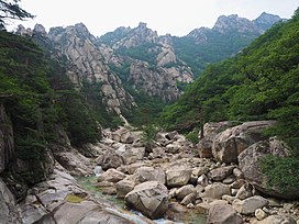
Mount Kumgang (Korean: 금강산; RR: Geumgangsan; MR: Kŭmgangsan; lit. Diamond Mountain) or the Kumgang Mountains is a mountain massif, with a 1,638-metre-high (5,374 ft) peak, in Kangwon-do, North Korea. It is located on the east coast of the country, in Mount Kumgang Tourist Region, formerly part of Kangwŏn Province, and is part of the Taebaek mountain range which runs along the east of the Korean Peninsula. The mountain is about 50 kilometres (31 mi) from the South Korean city of Sokcho in Gangwon-do.