Mount Lindesay Highway Beaudesert Road | |
|---|---|
 | |
| Mount Lindesay Highway (green and black) | |
| General information | |
| Type | Highway |
| Length | 116 km (72 mi)[1] |
| Route number(s) | |
| Major junctions | |
| North end | Moorooka, Brisbane |
| |
| South end | QLD/NSW border |
| Location(s) | |
| Major settlements | Jimboomba, Beaudesert, Rathdowney |
| Highway system | |
| ---- | |
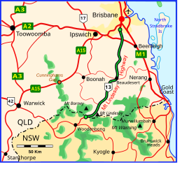
Mount Lindesay Highway is an Australian national highway located in Queensland. The highway runs southwest from Brisbane, where it leaves Ipswich Road in the suburb of Moorooka (as Beaudesert Road to the Logan Motorway), to the Queensland – New South Wales border and is 116 kilometres (72 mi) in length.[1] For most of its length it is roughly aligned with the Sydney–Brisbane rail corridor. At its southern end these transport routes take different passes over the Scenic Rim into the Northern Rivers region. It is designated National Route 13.[2]
- ^ a b "Mount Lindesay Highway" (Map). Google Maps. Retrieved 20 September 2022.
- ^ Queensland Government - Department of Transport and Main Roads - Maps