| Mount Longdon | |
|---|---|
 | |
| Highest point | |
| Elevation | 183 m (600 ft)[1] |
| Prominence | 97 m (318 ft)[2] |
| Isolation | 3 km (2 mi) |
| Coordinates | 51°40′15″S 57°58′55″W / 51.67083°S 57.98194°W |
| Geography | |
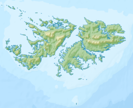
Mount Longdon is a hill located in the east of East Falkland island forming part of the Falkland Islands Archipelago.[3][4] It has an elevation of 183 metres (600 ft) above sea level. It is the highest land in any direction for 3 kilometres (2 miles).[5][a] Mount Longdon is named after Lt Col Richard Longdon, who was the commanding officer of the 2nd Battalion, Parachute Regiment (2 Para) of the British Army during the Falklands War.[6] It is best known as the site of the Battle of Mount Longdon, and overlooks Stanley, the capital of the Falkland Islands.
- ^ "ACME mapper". ACME mapper. 2024. Retrieved 11 October 2024.
- ^ "Peak Visor". Peak Visor. 2024. Retrieved 14 October 2024.
- ^ Alan Edwin Day (1996). The Falkland Islands, South Georgia and the South Sandwich Islands. Clio Press. p. 232.
- ^ Toponymic information is based on the Geographic Names Database, containing official standard names approved by the United States Board on Geographic Names and maintained by the National Geospatial-Intelligence Agency. More information is available at the Resources link at www.nga.mil. The National Geospatial-Intelligence Agency name, initials, and seal are protected by 10 United States Code § Section 425.
- ^ "Isolation for Mount Longdon - ACME mapper".
- ^ "Mount Longdon". Paradata. 2024. Retrieved 11 October 2024.
Cite error: There are <ref group=lower-alpha> tags or {{efn}} templates on this page, but the references will not show without a {{reflist|group=lower-alpha}} template or {{notelist}} template (see the help page).
