| Mount Martha Melbourne, Victoria | |||||||||||||||
|---|---|---|---|---|---|---|---|---|---|---|---|---|---|---|---|
 Esplanade road into Mount Martha | |||||||||||||||
 | |||||||||||||||
| Coordinates | 38°16′01″S 145°01′05″E / 38.267°S 145.018°E | ||||||||||||||
| Population | 19,846 (2021 census)[1] | ||||||||||||||
| • Density | 1,154/km2 (2,988/sq mi) | ||||||||||||||
| Postcode(s) | 3934 | ||||||||||||||
| Area | 17.2 km2 (6.6 sq mi) | ||||||||||||||
| Location | |||||||||||||||
| LGA(s) | Shire of Mornington Peninsula | ||||||||||||||
| State electorate(s) | |||||||||||||||
| Federal division(s) | Flinders | ||||||||||||||
| |||||||||||||||


Mount Martha is a suburb on the Mornington Peninsula in Melbourne, Victoria, Australia, 50 kilometres (31 mi) south-east of Melbourne's Central Business District, located within the Shire of Mornington Peninsula local government area. Mount Martha recorded a population of 19,746 at the 2021 census.[1]
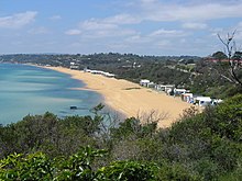
Mount Martha is located on the southeastern shores of Port Phillip and offers a bathing beach. A boardwalk winds its way for more than 5 kilometres (3 mi) along the Balcombe Creek, its North beach mouth to the Briars Historic Park. The suburb's highest point bears the area's name and reaches 160 metres (520 ft). The peak was named in 1836 after Captain William Hobson's mother, Martha Jones.[2]
It marks the start of the Selwyn fault, a geological formation that runs to the eastern Dandenong Ranges.
- ^ a b Australian Bureau of Statistics (28 June 2022). "Mount Martha (Suburbs and Localities)". 2021 Census QuickStats. Retrieved 12 July 2022.
- ^ "Victorian Historical Journal" (PDF). Retrieved 19 March 2020.
