| Mount Owen | |
|---|---|
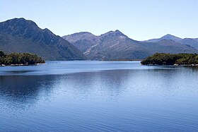
 East Mount Owen wall and Lake Burbury from Bradhsaws Bridge | |
| Highest point | |
| Elevation | 1,146 m (3,760 ft)[1] |
| Prominence | 774 m (2,539 ft)[1] |
| Isolation | 8.53 km (5.30 mi)[1] |
| Coordinates | 42°05′24″S 145°36′00″E / 42.09000°S 145.60000°E[2] |
| Geography | |
Location in Tasmania | |
| Location | West Coast, Tasmania, Australia |
| Parent range | West Coast Range |
| Climbing | |
| Easiest route | from North West along track to TV tower |
Mount Owen is a mountain directly east of the town of Queenstown on the West Coast Range in Western Tasmania, Australia.
With an elevation of 1,146 metres (3,760 ft) above sea level,[1] like most of the mountains in the West Coast Range, it was named by the geologist Charles Gould after Richard Owen. The taller mountains were named after opponents or critics of Charles Darwin, the smaller after his supporters. The north western slopes are clearly seen from Gormanston and the Linda Valley 'Long Spur'.[3]
- ^ a b c d "Mount Owen, Australia". Peakbagger.com. Retrieved 16 June 2015.
- ^ "Mount Owen (TAS)". Gazetteer of Australia online. Geoscience Australia, Australian Government.
- ^ Baillie, Peter (2010). "The West Coast Range, Tasmania: Mountains and Geological Giants" (PDF). Papers and Proceedings of the Royal Society of Tasmania. 144 (reprint ed.). Hobart, Tasmania: University of Tasmania: 1–13. doi:10.26749/rstpp.144.1. ISSN 0080-4703. S2CID 126902525. Archived from the original (PDF) on 16 June 2015. Retrieved 18 June 2015.
