| Mount Robson Provincial Park | |
|---|---|
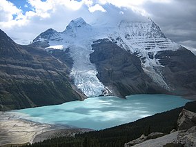
 Mt. Robson's north face, Berg and Mist glaciers calving into Berg Lake | |
Location of Mount Robson Provincial Park in Canada | |
| Location | British Columbia, Canada |
| Nearest city | Valemount, Jasper |
| Coordinates | 53°02′02″N 119°13′54″W / 53.03389°N 119.23167°W |
| Area | 2,249 km2 (868 sq mi) |
| Established | 1913 |
| Governing body | BC Parks |
| Website | bcparks |

| |
| Part of | Canadian Rocky Mountain Parks |
| Criteria | Natural: (vii), (viii) |
| Reference | 304 |
| Inscription | 1990 (14th Session) |
Mount Robson Provincial Park is a provincial park in the Canadian Rockies with an area of 2,249 km2. The park is located entirely within British Columbia, bordering Jasper National Park in Alberta. The B.C. legislature created the park in 1913, the same year as the first ascent of Mount Robson by a party led by Conrad Kain. It is the second oldest park in the provincial system.[2] The park is named for Mount Robson, which has the highest point in the Canadian Rockies and is located entirely within the park.
- ^ "Protected Planet | Mount Robson Park". Protected Planet. Retrieved October 13, 2020.
- ^ "Mount Robson Provincial Park and Protected Area/Mount Robson Corridor Protected Area - BC Parks". www.env.gov.bc.ca. Retrieved March 14, 2016.
