| Mount Royal | |
|---|---|
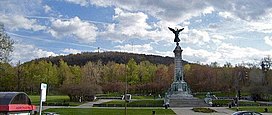
 George-Étienne Cartier Monument and Mount Royal's eastern slope | |
| Highest point | |
| Elevation | 233 m (764 ft) |
| Prominence | 227 m (745 ft) |
| Isolation | 32.68 km (20.31 mi) |
| Coordinates | 45°30′23″N 73°35′20″W / 45.50639°N 73.58889°W |
| Naming | |
| Native name | Mont Royal (French) |
| Geography | |
| Country | Canada |
| Province | Quebec |
| City | Montréal |
| Parent range | Monteregian Hills |
| Topo map | NTS 31H12 Laval |
| Geology | |
| Rock age | Early Cretaceous |
| Mountain type | Intrusive stock |
| Climbing | |
| First ascent | Jacques Cartier, 1535 (first European) |
| Easiest route | Hike or Cycling |
Mount Royal (French: Mont Royal, IPA: [mɔ̃ ʁwajal]) is a mountain in the city of Montreal, immediately west of Downtown Montreal, Quebec, Canada. The city's name is thought to be derived from the mountain's name.[1]
The mountain is part of the Monteregian Hills situated between the Laurentians and the Appalachian Mountains. It gave its Latin name, Mons Regius, to the Monteregian chain. The mountain consists of three peaks: Colline de la Croix (or Mont Royal proper) at 233 m (764 ft), Colline d'Outremont (or Mount Murray, in the borough of Outremont) at 211 m (692 ft), and Westmount Summit at 201 m (659 ft) elevation above mean sea level.
