| Mount Tamalpais | |
|---|---|
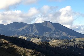
 Mount Tamalpais, viewed from the southeast | |
| Highest point | |
| Elevation | 2,579 ft (786 m) NAVD 88[1] |
| Prominence | 2,456 ft (749 m)[1] |
| Listing | California county high points 55th |
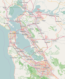
| Coordinates | 37°55′45″N 122°34′40″W / 37.929088°N 122.577829°W[1] |
| Naming | |
| Native name |
|
| Geography | |
| Location | Marin County, California, U.S. |
| Parent range | California Coast Ranges |
| Topo map | USGS San Rafael |
| Geology | |
| Mountain type | Sedimentary |
| Climbing | |
| First ascent | 1830s by Jacob P. Leese (first recorded ascent)[2] |
| Easiest route | Railroad Grade fire trail |
Mount Tamalpais (/tæməlˈpaɪɪs/; TAM-əl-PY-iss; Miwok: Támal Pájiṣ), known locally as Mount Tam, is a peak in Marin County, California, United States, often considered symbolic of Marin County. Much of Mount Tamalpais is protected within public lands such as Mount Tamalpais State Park, the Marin Municipal Water District watershed, and National Park Service land, such as Muir Woods.


