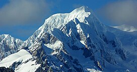
| Mount Tasman | |
|---|---|
 | |
| Highest point | |
| Elevation | 3,497 m (11,473 ft) |
| Prominence | 519 m (1,703 ft) |
| Listing | New Zealand #2 |
| Coordinates | 43°34′S 170°9′E / 43.567°S 170.150°E |
| Naming | |
| Native name | Te Horokōau (Māori) |
| Geography | |
| Parent range | Southern Alps |
| Climbing | |
| First ascent | February 1895 by Edward Fitzgerald, Matthias Zurbriggen und Jack Clarke |
| Easiest route | glacier/snow/ice climb |
Mount Tasman (Te Horokōau in Māori)[1][2] is New Zealand's second-highest mountain, rising to a height of 3,497 metres (11,473 ft). It is located in the Southern Alps of the South Island, four kilometres to the north of its larger neighbour, Aoraki / Mount Cook. Unlike Aoraki / Mount Cook, Mount Tasman sits on the South Island's Main Divide, on the border between Aoraki / Mount Cook National Park and Westland Tai Poutini National Park. It is the highest point in Westland District.[citation needed]
The first ascent of Mount Tasman was in 1895 by Edward FitzGerald and his guide Matthias Zurbriggen.[3]
The Māori name (horo: to swallow; koau: shag or Phalacrocorax varius) is believed to refer to the swelling in the neck of a shag when it is swallowing a fish.[4]
- ^ "Place name detail: Te Horokōau". New Zealand Gazetteer. New Zealand Geographic Board. Retrieved 16 November 2023.
- ^ "Useful Documents | District Plan Review Stage Three | Let's Talk | Kōrero Mai – Mackenzie". letstalk.mackenzie.govt.nz. p. 11. Retrieved 16 November 2023.
- ^ Wilson, John. "Mountaineering – Aoraki/Mt Cook". Te Ara: The Encyclopedia of New Zealand. Retrieved 5 December 2020.
- ^ Reed, A. W. (2010). Peter Dowling (ed.). Place Names of New Zealand. Rosedale, North Shore: Raupo. p. 391. ISBN 9780143204107.
