| Mount Townsend | |
|---|---|
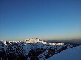
 Dawn on Mount Townsend, viewed from Watsons Crags, October 2011. | |
| Highest point | |
| Elevation | 2,209 m (7,247 ft)[1] |
| Prominence | 189 m (620 ft)[1] |
| Isolation | 3.71 km (2.31 mi)[1] |
| Listing | Seven Second Summits |
| Coordinates | 36°25′21″S 148°15′32″E / 36.42250°S 148.25889°E[2] |
| Naming | |
| Etymology | Thomas Scott Townsend |
| Geography | |
Location in New South Wales | |
| Location | Snowy Mountains, New South Wales, Australia |
| Parent range | Main Range, Great Dividing Range |
| Topo map | Youngal |
| Climbing | |
| Easiest route | Hike or ski |
Mount Townsend, a mountain in the Main Range of the Great Dividing Range, is located in the Snowy Mountains region of New South Wales, Australia.
With an elevation of 2,209 metres (7,247 ft) above sea level,[1] Mount Townsend is the second-highest peak of mainland Australia. Located in Kosciuszko National Park, the mountain is 3.68 kilometres (2.29 mi) north of Australia's highest mainland peak, Mount Kosciuszko.
Although lower than Mount Kosciuszko, Mount Townsend has a more craggy peak and is arguably more dominant than the relatively round-topped Mount Kosciuszko.
The confusion about swapping the names of Mount Kosciuszko and Mount Townsend was straightened out in 1940 by B. T. Dowd,[3] a cartographer and historian of the NSW Lands Department. His study reaffirmed that the mountain named by Strzelecki as Mount Kosciuszko was indeed, as the NSW maps had always shown, Australia's highest summit. When Macarthur's field book of the historical journey was published in 1941 by C. Daley[4] it further confirmed Dowd's clarification. This means that Targangil, mentioned in Spencer's 1885 article,[5] was the indigenous name of Mount Townsend, not of Mount Kosciuszko.
Mount Townsend has a prominence of only 189m which is relatively low compared to other mountains worldwide. By stricter prominence cut off points, the most common of which being the 300m prominence rule, Townsend would not be classified as its own mountain, and instead a subsidiary peak. Due to Australia's much flatter topography than all other continents, a prominence cut off point of 300m is almost never used, cartographers opting instead for less strict definitions, such as 50m or 100m when classifying peaks. If using the 300m rule this makes Mount Bogong in Victoria the second highest mountain.
- ^ a b c d "Mount Townsend". Peakbagger.com. Retrieved 22 July 2012.
- ^ "Mount Townsend". Geographical Names Register (GNR) of NSW. Geographical Names Board of New South Wales. Retrieved 27 May 2015.
- ^ Dowd, B.T. The Cartography of Mount Kosciusko. Royal Australian Historical Society. Journal & Proceedings, vol. 26, part I, pp. 97-107
- ^ C. Daley Count Paul Strzelecki’s Ascent of Mount Kosciusko and Journey through Gippsland The Victorian Historical Magazine, vol.19, no 2, pp. 41-53, 1941
- ^ " M. Spencer The Highest Point in Australia The Sydney Morning Herald, February 18, 1885",
