| Mount Wellington | |
|---|---|
| kunanyi | |
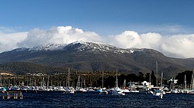
 Mount Wellington viewed from Lindisfarne Bay on the Eastern Shore of the River Derwent, with its seasonal snow cap visible | |
| Highest point | |
| Elevation | 1,271 m (4,170 ft)[1] |
| Prominence | 693 m (2,274 ft)[1] |
| Isolation | 47.56 km (29.55 mi)[1] |
| Listing | 49th highest mountain of Tasmania |
| Coordinates | 42°53′45.6″S 147°14′14.3″E / 42.896000°S 147.237306°E[2] |
| Geography | |
Location in Tasmania | |
| Location | South East Tasmania, Australia |
| Parent range | Wellington |
| Geology | |
| Mountain type | Dolerite |
| Climbing | |
| First ascent |
|
| Easiest route | Hike, road |
Mount Wellington, also known as kunanyi (palawa kani: /kuːˈnɑːnjiː/) and gazetted as kunanyi / Mount Wellington[3] is a mountain in the south-east of Tasmania, Australia. It is the summit of the Wellington Range and is within Wellington Park reserve. Hobart, Tasmania's capital city, is located at the foot of the mountain.
The mountain rises 1,271 metres (4,170 ft) above sea level[1] and is frequently covered by snow, at times even in summer, and the lower slopes are thickly forested, but crisscrossed by many walking tracks and a few fire trails.[4] There is also a sealed narrow road to the summit, about 22 kilometres (14 mi) from Hobart central business district. An enclosed lookout near the summit has views of the city below and to the east, the Derwent estuary, and also glimpses of the World Heritage Area nearly 100 kilometres (62 mi) west. From Hobart, the most distinctive feature of Mount Wellington is the cliff of dolerite columns known as the Organ Pipes.
- ^ a b c d "Mount Wellington, Australia". Peakbagger.com. Retrieved 7 June 2015.
- ^ "Mount Wellington (TAS)". Gazetteer of Australia online. Geoscience Australia, Australian Government.
- ^ Cite error: The named reference
abcnamewas invoked but never defined (see the help page). - ^ "Wellington Park – Bush walking". Retrieved 24 October 2013.
