Mpumalanga
iMpumalanga iPumalanga | |
|---|---|
|
| |
| Motto: Omnia labor vincit (Labour will conquer all) | |
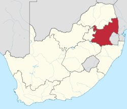
 Location of Mpumalanga in South Africa | |
| Country | South Africa |
| Established | 27 April 1994 |
| Capital | Mbombela |
| Districts | |
| Government | |
| • Type | Parliamentary system |
| • Premier | Mandla Ndlovu (ANC) |
| • Legislature | Mpumalanga Provincial Legislature |
| Area [1]: 9 | |
| • Total | 76,495 km2 (29,535 sq mi) |
| • Rank | 8th in South Africa |
| Highest elevation | 2,331 m (7,648 ft) |
| Population (2022)[2] | |
| • Total | 5,142,216 |
| • Rank | 6th in South Africa |
| • Density | 67/km2 (170/sq mi) |
| • Rank | 3rd in South Africa |
| Population groups (2022) | |
| • Black | 95.3% |
| • White | 3.6% |
| • Coloured | 0.6% |
| • Indian or Asian | 0.5% |
| • Other | 0.5% |
| Languages (2022) | |
| • Swazi | 30.5% |
| • Zulu | 27.8% |
| • Tsonga | 10.6% |
| • Pedi | 10.3% |
| • Southern Ndebele | 9.9% |
| • Afrikaans | 3.2% |
| • Southern Sotho | 2.3% |
| • English | 1.5% |
| Time zone | UTC+2 (SAST) |
| ISO 3166 code | ZA-MP |
| HDI (2019) | 0.675[3] medium · 7th of 9 |
| GDP | US$58.2 billion[4] |
| Website | www |
26°S 30°E / 26°S 30°E Mpumalanga (/əmˌpuːməˈlɑːŋɡə/) is one of the nine provinces of South Africa. The name means "East", or literally "The Place Where the Sun Rises" in the Nguni languages. Mpumalanga lies in eastern South Africa, bordering Eswatini and Mozambique. It shares borders with the South African provinces of Limpopo to the north, Gauteng to the west, the Free State to the southwest, and KwaZulu-Natal to the south. The capital is Mbombela.[5]
| Zulu | iMpumalanga |
|---|---|
| Afrikaans | Mpumalanga |
| Sepedi | Mpumalanga |
| Swazi | eMpumalanga |
| Setswana | Botlhabatsatsi |
| Xitsonga | Vuhuma-dyambu |
| Southern Ndebele | iPumalanga |
Mpumalanga was formed in 1994, when the area that was the Eastern Transvaal was merged with the former bantustans KaNgwane, KwaNdebele and parts of Lebowa and Gazankulu. Although the contemporary borders of the province were only formed at the end of apartheid, the region and its surroundings have a history that extends back thousands of years. Much of its history, and current significance is as a region of trade.[6]
- ^ Census 2011: Census in brief (PDF). Pretoria: Statistics South Africa. 2012. ISBN 978-0-621-41388-5. Archived (PDF) from the original on 13 May 2015.
- ^ a b c "Statistical Release - Census 2022" (PDF). statssa.gov.za. Retrieved 22 August 2024.
- ^ "Sub-national HDI – Area Database – Global Data Lab". hdi.globaldatalab.org. Retrieved 13 September 2018.
- ^ "Provincial gross domestic product:experimental estimates, 2013–2022" (PDF), www.statssa.gov.za
- ^ "Home". www.mbombela.gov.za. Retrieved 25 May 2022.
- ^ Delius, Peter (2007). Mpumalanga : history and heritage. University of Kwazulu-Natal Press. OCLC 608393212.

