Mueang Chonburi
เมืองชลบุรี | |
|---|---|
 The Khao Khiao Massif rising east of Chonburi | |
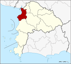
 District location in Chonburi province | |
| Coordinates: 13°21′43″N 100°58′45″E / 13.36194°N 100.97917°E | |
| Country | Thailand |
| Province | Chonburi |
| Seat | Bang Pla Soi |
| Area | |
| • Total | 228.8 km2 (88.3 sq mi) |
| Population (2015) | |
| • Total | 322,057 |
| • Density | 1,407.59/km2 (3,645.6/sq mi) |
| Time zone | UTC+7 (ICT) |
| Postal code | 20000[1] |
| Geocode | 2001 |
Mueang Chonburi (Thai: เมืองชลบุรี, RTGS: Mueang Chon Buri, pronounced [mɯ̄a̯ŋ t͡ɕʰōn bū.rīː]) is the capital district (amphoe mueang) of Chonburi province, eastern Thailand.