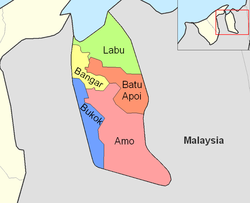
Mukim Amo | |
|---|---|
 Ulu Temburong National Park | |
 Amo is in red. | |
| Coordinates: 4°34′32″N 115°07′25″E / 4.5756533°N 115.1234737°E | |
| Country | Brunei |
| District | Temburong |
| Government | |
| • Penghulu | Suhaili Badas[1] |
| Area | |
| • Total | 542 km2 (209 sq mi) |
| Population (2021)[3] | |
| • Total | 1,657 |
| • Density | 3.1/km2 (7.9/sq mi) |
| Time zone | UTC+8 (BNT) |
| Postcode | PDxx51 |
Mukim Amo is a mukim in Temburong District, Brunei. It has an area of 542 square kilometres (209 sq mi);[2] the population was 1,657 in 2021.[4]
- ^ BUKU DIREKTORI TELEFON PENGHULU-PENGHULU MUKIM DAN KETUA-KETUA KAMPUNG NEGARA BRUNEI DARUSSALAM (PDF) (in Malay). Vol. 4. Brunei: Bahagian Perancangan Daerah, Ministry of Home Affairs. April 2024. p. 33.
- ^ a b "Jabatan Daerah Temburong, Kementerian Hal Ehwal Dalam Negeri - MUKIM AMO". temburong.gov.bn (in Malay). Retrieved 8 January 2018.
- ^ Cite error: The named reference
Annex-B2was invoked but never defined (see the help page). - ^ Department of Economic Planning & Statistics (October 2021). "ANNEX B" (PDF). deps.mofe.gov.bn. Retrieved 24 January 2024.