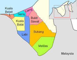
Mukim Labi | |
|---|---|
 Luagan Lalak Forest Recreational Park | |
 Labi is in blue. | |
| Coordinates: 4°25′18″N 114°27′48″E / 4.42167°N 114.46333°E | |
| Country | Brunei |
| District | Belait |
| Government | |
| • Penghulu | Nurazri Abdul Mustafah (Acting)[1] |
| Area | |
| • Total | 361.8 km2 (139.7 sq mi) |
| Population (2021)[3] | |
| • Total | 727 |
| • Density | 2.0/km2 (5.2/sq mi) |
| Time zone | UTC+8 (BNT) |
| Postcode | KExx37 |
Mukim Labi is a mukim in the interior of Belait District, Brunei.[4] It has an area of 361.8 square kilometres (139.7 sq mi);[2] the population was 1,216 in 2016.[5]
- ^ BUKU DIREKTORI TELEFON PENGHULU-PENGHULU MUKIM DAN KETUA-KETUA KAMPUNG NEGARA BRUNEI DARUSSALAM (PDF) (in Malay). Vol. 4. Brunei: Bahagian Perancangan Daerah, Ministry of Home Affairs. April 2024. p. 19.
- ^ a b "Crown Prince Visits Ulu Belait". Brudirect.com. Archived from the original on 28 September 2007. Retrieved 23 July 2007.
- ^ Cite error: The named reference
Annex-B2was invoked but never defined (see the help page). - ^ "Belait District" (PDF). www.information.gov.bn. 2011. pp. 8–9. Retrieved 28 June 2021.
- ^ "Population and Housing Census Update Final Report 2016" (PDF). www.deps.gov.bn. Statistics Department. December 2018. Retrieved 27 June 2021.