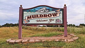
Muldrow, Oklahoma | |
|---|---|
| Town of Muldrow | |
 Welcome sign on State Highway 64B | |
 Location in the state of Oklahoma | |
Location in the United States | |
| Coordinates: 35°24′22.3″N 94°35′55.8″W / 35.406194°N 94.598833°W | |
| Country | |
| State | |
| County | Sequoyah |
| Founded | November 19, 1887 |
| Named for | Henry L. Muldrow |
| Government | |
| • Type | Mayor–Council |
| Area | |
| • Total | 4.29 sq mi (11.11 km2) |
| • Land | 4.24 sq mi (10.98 km2) |
| • Water | 0.05 sq mi (0.13 km2) |
| Elevation | 505 ft (154 m) |
| Population (2020) | |
| • Total | 3,272 |
| • Density | 771.88/sq mi (298.04/km2) |
| Time zone | UTC-6 (Central (CST)) |
| • Summer (DST) | UTC-5 (CDT) |
| ZIP code(s) | 74948 |
| Area code(s) | 539, 918 |
| FIPS code | 40-49850[3] |
| GNIS feature ID | 2413026[2] |
| Major airport | FSM |
Muldrow, officially the Town of Muldrow, is a town in Sequoyah County, Oklahoma, United States. It is part of the Fort Smith, Arkansas–Oklahoma Metropolitan Statistical Area. The population was 3,466 at the 2010 census, an increase of 11.7 percent over the figure of 3,104 recorded in 2000.[4]
- ^ "ArcGIS REST Services Directory". United States Census Bureau. Retrieved September 20, 2022.
- ^ a b U.S. Geological Survey Geographic Names Information System: Muldrow, Oklahoma
- ^ "U.S. Census website". United States Census Bureau. Retrieved January 31, 2008.
- ^ CensusViewer: Population of the City of Muldrow, Oklahoma
