| Mungo National Park New South Wales | |
|---|---|
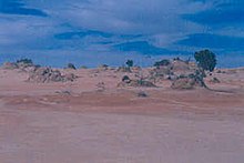
Red Top Formation & Lookout, looking north toward Wilcannia, 2024. | |
| Nearest town or city | Pooncarie |
| Coordinates | 33°44′56″S 143°08′08″E / 33.74889°S 143.13556°E |
| Established | 6 April 1979[1] |
| Area | 1,109.67 km2 (428.4 sq mi)[1] |
| Managing authorities | NSW National Parks & Wildlife Service |
| Website | Mungo National Park |
| See also | Protected areas of New South Wales |


Mungo National Park is a protected national park that is located in south-western New South Wales, in eastern Australia. The 110,967-hectare (274,210-acre) national park is situated approximately 875 kilometres (544 mi) west of Sydney in the Balranald Shire.
Mungo National Park is the traditional meeting place of the Muthi Muthi, Nyiampaar and Barkinji Aboriginal Nations. People are no longer able to climb the sand dunes by themselves as stricter rules have been enforced, all visitors groups need to be accompanied by an accredited tour guide to access the sand dunes.
The national park is part of the UNESCO World Heritage–listed Willandra Lakes Region, an area of 2,400 square kilometres (930 sq mi) that incorporates seventeen dry lakes. The seventeen dry lakes are not all called Mungo but are all declared world heritage. The creek that used to flow into Mungo is being preserved as a sacred site. The national park is about 75 kilometres (47 mi) south-east of Pooncarie, 110 kilometres (68 mi) north-east of Mildura and approximately 145 kilometres (90 mi), 90 minutes drive south-west of Ivanhoe. The roads to, in or around the park are unsealed and can be accessed in 2-wheel-drive cars, but councils will close the road in wet weather.
- ^ a b "Mungo National Park: Park management". Office of Environment & Heritage. Government of New South Wales. Retrieved 12 October 2014.

