McCreary | |
|---|---|
| Municipality of McCreary | |
| Nickname(s): The Ski and Maple Syrup Capital of Manitoba[1] | |
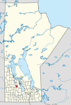
 Location of the RM of McCreary in Manitoba | |
| Coordinates: 50°44′58″N 99°29′06″W / 50.74944°N 99.48500°W | |
| Country | Canada |
| Province | Manitoba |
| Region | Parkland |
| Census division | No. 17 |
| Incorporated (amalgamated) | January 1, 2015[2] |
| Government | |
| • Reeve | Mike Gawaziuk |
| Area | |
| • Total | 527.77 km2 (203.77 sq mi) |
| Elevation | 302 m (991 ft) |
| Population | |
| • Total | 748 |
| • Density | 1.4/km2 (3.7/sq mi) |
| Time zone | UTC-6 (CST) |
| • Summer (DST) | UTC-5 (CDT) |
| Postal code | R0J 1B0 |
| Website | exploremccreary |
The Municipality of McCreary is a rural municipality (RM) in the Parkland Region of Manitoba, Canada.
Geographically located between Riding Mountain National Park and Lake Manitoba, the majority of the municipal lands are within the drainage basin of the Turtle River.[4]
It is the self-proclaimed "Ski and Maple Syrup Capital of Manitoba."[1]
- ^ a b "Municipality".
- ^ Cite error: The named reference
2015amalgwas invoked but never defined (see the help page). - ^ "Population and dwelling counts: Canada, provinces and territories, and census subdivisions (municipalities), Manitoba". Statistics Canada. February 9, 2022. Retrieved February 20, 2022.
- ^ "location". exploremccreary.com. Retrieved August 5, 2021.