Native name: Munrothuruthu | |
|---|---|
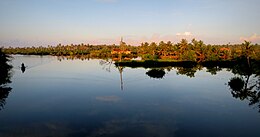
 Lake Ashtamudi at Munroe Island | |
| Etymology | In honour of Col. John Munro |
| Geography | |
| Location | Ashtamudi Lake in India |
| Coordinates | 9°0′0″N 76°37′0″E / 9.00000°N 76.61667°E |
| Archipelago | Islands of Kollam |
| Adjacent to | Lake Ashtamudi |
| Total islands | 8 |
| Major islands | Munroe Island,Perungalam, Pattamthuruth, Pezhumthuruth |
| Area | 13.37 km2 (5.16 sq mi) |
| Administration | |
| Largest Metropolis | Kollam (Quilon) (pop. 397419) |
| Demographics | |
| Population | 10380 (2011) |
| Pop. density | 776/km2 (2010/sq mi) |
| Ethnic groups | Malayali |
| Additional information | |
| Time zone | |
| Official website | www |
| The nearest Railway Station is Munroturuttu railway station. | |
Munroe Island (Malayalam: മണ്റോത്തുരുത്ത്) or Mundrothuruthu is an inland island group located at the confluence of Ashtamudi Lake and the Kallada River, in Kollam district, Kerala, South India. It is a group of eight small islets comprising a total area of about 13.4 km2.[1] The island, accessible by road, rail and inland water navigation, is about 25 kilometres (16 mi) from Kollam by road, 38 kilometres (24 mi) north from Paravur, 12 kilometres (7.5 mi) west from Kundara and about 25 kilometres (16 mi) from Karunagapally. As of the 2011 Indian census[update], the administrative village of Mundrothuruth (which includes nearby small villages as well) has a total population of 9599, consisting of 4636 males and 4963 females. This island is also known as "Sinking Island of Kerala".
The place is named in honour of Resident Colonel John Munro of the former Princely State of Travancore. The islands measure 13.4 square kilometres (5.2 sq mi) in area.
- ^ "Floating houses at Munroe Thuruthu?". Times Of India. 15 May 2019. Retrieved 15 May 2019.
