| Murchison River | |
|---|---|
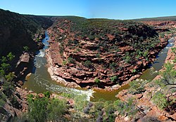
 View of Murchison Gorge from the Z Bend lookout | |
 | |
| Location | |
| Country | Australia |
| Physical characteristics | |
| Source | |
| • location | Robinson Ranges |
| • elevation | 521 m (1,709 ft)[2] |
| Mouth | |
• location | Indian Ocean, at Kalbarri |
| Length | 820 km (510 mi)[1] |
| Basin size | 82,000 km2 (31,660 sq mi) |
| Discharge | |
| • average | 208,400 ML/a (6.60 m3/s; 233.2 cu ft/s)[3][4] |
| Basin features | |
| Tributaries | |
| • left | Yalgar River, Whela Creek, Impey River, Roderick River, Sanford River, Yalgamine Creek |
| • right | Bedaburra Creek |


The Murchison River is the second longest river in Western Australia. It flows for about 820 km (510 mi)[1] from the southern edge of the Robinson Ranges to the Indian Ocean at Kalbarri. The Murchison-Yalgar-Hope river system is the longest river system in Western Australia. It has a mean annual flow of 208 gigalitres, although in 2006, the peak year on record since 1967, flow was 1,806 gigalitres.[3][1][5]
- ^ a b c "Interesting facts about Western Australia". Landgate. Western Australian Land Information Authority. Archived from the original on 13 July 2012. Retrieved 6 May 2012.
- ^ "Bonzle Digital Atlas – Map of Murchison River, WA". 2008. Retrieved 26 November 2008.
- ^ a b "Murchison River - Emu Springs". Water Information reporting. Perth, WA: Department of Water, Government of Western Australia. 6 December 2016. Retrieved 13 April 2017.
- ^ "702 – Murchison River Basin". Water Resources Data – Streamflow Sites. Government of Western Australia Department of Water. 2 July 2012. Archived from the original on 23 August 2008. Retrieved 3 July 2012.
- ^ Mt Magnet Water Reserve: Water Source Protection Plan, Mt Magnet Town Water Supply (pdf). Perth, WA: Department of Environment. 2005. p. 3. ISBN 0-7309-7510 - X. Retrieved 31 December 2015.