Murghob District
Tajik: Ноҳияи Мурғоб | |
|---|---|
| Ноҳияи Мурғоб | |
 | |
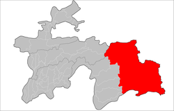
 Location of Murghob District in Tajikistan | |
| Coordinates: 38°10′N 73°55′E / 38.167°N 73.917°E | |
| Country | |
| Region | Gorno-Badakhshan Autonomous Region |
| Capital | Murghob |
| Area | |
| • Total | 37,300 km2 (14,400 sq mi) |
| Population (2020)[1] | |
| • Total | 15,900 |
| • Density | 0.43/km2 (1.1/sq mi) |
| Time zone | UTC+5 (TJT) |
| Postal code | 736600 |
| Area code | +992 3554 |
| Official languages | |

Murghob District (Tajik: Ноҳияи Мурғоб) is a district in Tajikistan, occupying the eastern two-thirds of the Gorno-Badakhshan Autonomous Region (GBAO). The area of Murghob District is 37,300 km2, covering 26 percent of Tajikistan's soil, but only 0.17% of its population.[3] Murghob District borders on Kyrgyzstan to the north, China to the east, and Afghanistan to the south.[4] The population of Murghob District is 15,900 (1 January 2020 estimate).[1] Its administrative capital is the village Murghob (also known as Murghab).
- ^ a b "Population of the Republic of Tajikistan as of 1 January 2020" (PDF) (in Russian). Statistics office of Tajikistan. Archived from the original (PDF) on 30 July 2021. Retrieved 7 October 2020.
- ^ "КОНСТИТУЦИЯ РЕСПУБЛИКИ ТАДЖИКИСТАН". prokuratura.tj. Parliament of Tajikistan. Retrieved 9 January 2020.
- ^ Cite error: The named reference
regionswas invoked but never defined (see the help page). - ^ Borjian, Habib, “Morḡāb” , Encyclopaedia Iranica. Online 2013. [1].