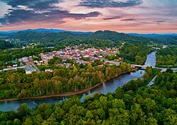
Murphy, North Carolina | |
|---|---|
 Murphy next to the Hiwassee River | |
| Nickname: City of Flowers | |
 Location of Murphy, North Carolina | |
| Coordinates: 35°05′36″N 84°01′41″W / 35.09333°N 84.02806°W | |
| Country | United States |
| State | North Carolina |
| County | Cherokee |
| Founded by | A. R. S. Hunter |
| Named for | Archibald Murphey |
| Area | |
| • Total | 2.65 sq mi (6.85 km2) |
| • Land | 2.54 sq mi (6.57 km2) |
| • Water | 0.11 sq mi (0.28 km2) |
| Elevation | 1,539 ft (469 m) |
| Population (2020) | |
| • Total | 1,608 |
| • Density | 633.82/sq mi (244.70/km2) |
| Time zone | UTC−5 (Eastern (EST)) |
| • Summer (DST) | UTC−4 (EDT) |
| ZIP code | 28906 |
| Area code | 828 |
| FIPS code | 37-45660[3] |
| GNIS feature ID | 2406220[2] |
| Website | www |
Murphy is a town in and the county seat of Cherokee County, North Carolina, United States.[4] It is situated at the confluence of the Hiwassee and Valley rivers. It is the westernmost county seat in the state of North Carolina, approximately 360 miles (580 km) from the state capital in Raleigh. The population of Murphy was 1,608 at the 2020 census.[5][6]
- ^ "ArcGIS REST Services Directory". United States Census Bureau. Retrieved September 20, 2022.
- ^ a b U.S. Geological Survey Geographic Names Information System: Murphy, North Carolina
- ^ "U.S. Census website". United States Census Bureau. Retrieved January 31, 2008.
- ^ "Find a County". National Association of Counties. Archived from the original on May 31, 2011. Retrieved June 7, 2011.
- ^ "Geographic Identifiers: 2010 Demographic Profile Data (G001): Murphy town, North Carolina". U.S. Census Bureau, American Factfinder. Archived from the original on February 12, 2020. Retrieved December 30, 2014.
- ^ Bureau, U.S. Census. "U.S. Census website". United States Census Bureau. Retrieved July 6, 2017.
{{cite web}}:|last=has generic name (help)
