It has been suggested that this article be merged with Mer Island, Queensland. (Discuss) Proposed since September 2024. |
This article needs additional citations for verification. (July 2011) |
Native name: Mer | |
|---|---|
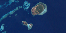
 A satellite image of Murray Island | |
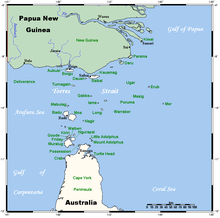
 A map of the Torres Strait Islands showing Mer in the northeastern waters of Torres Strait | |
| Geography | |
| Location | Northern Australia |
| Coordinates | 9°55′S 144°3′E / 9.917°S 144.050°E |
| Archipelago | Torres Strait Islands |
| Adjacent to | Torres Strait |
| Total islands | 3 |
| Major islands | 1 |
| Area | 4.29 km2 (1.66 sq mi) |
| Highest elevation | 234 m (768 ft) |
| Highest point | Gelam Paser |
| Administration | |
Australia | |
| State | Queensland |
| Regional Authority | Torres Strait Regional Authority |
| Local Government Area | Torres Strait Island Region |
| Demographics | |
| Population | 485 (2006 census) |
| Murray Island Queensland | |
|---|---|
| Coordinates | 9°54′50″S 144°02′31″E / 9.914°S 144.042°E |
| Population | 406 (2021 census)[1] |
| Postcode(s) | 4875 |
| Time zone | AEST (UTC+10:00) |
| LGA(s) | Torres Strait Island Region |
Murray Island (also known as Mer Island or Maer Island) in the Torres Strait Island Region, Queensland, Australia.[2][3] The island is part of the Murray Island Group in the Torres Strait.[4] The town is on the island's northwest coast and within the locality of Mer Island (the locality boundaries are the island's coastline).[5] The island is of volcanic origin, the most easterly inhabited island of the Torres Strait Islands archipelago, just north of the Great Barrier Reef. The name Meer/Mer/Maer comes from the native Meriam language. In the 2021 census, Mer Island had a population of 406 people.[1]
The island is populated by the Melanesian Meriam people. There are eight tribes on Mer: Komet, Zagareb, Meuram, Magaram, Geuram, Peibri, Meriam-Samsep, Piadram/Dauer. The island's organisation is based on traditional laws of boundary and ownership.
- ^ a b Cite error: The named reference
Census2021was invoked but never defined (see the help page). - ^ "Murray Island – population centre in the Torres Strait Island Region (entry 23612)". Queensland Place Names. Queensland Government. Retrieved 17 January 2020.
- ^ "Meer Island – island in the Torres Strait Island Region (entry 20523)". Queensland Place Names. Queensland Government. Retrieved 3 November 2019.
- ^ "Murray Island – island group in the Torres Strait Island Region (entry 23613)". Queensland Place Names. Queensland Government. Retrieved 17 January 2020.
- ^ "Mer Island – locality in the Torres Strait Island Region (entry 46717)". Queensland Place Names. Queensland Government. Retrieved 17 January 2020.
