| Mutitjulu Northern Territory | |||||||||
|---|---|---|---|---|---|---|---|---|---|
 | |||||||||
| Coordinates | 25°21′03″S 131°03′59″E / 25.35083°S 131.06639°E | ||||||||
| Population | 296 (2011 census)[1] | ||||||||
| Postcode(s) | 0872[2] | ||||||||
| Elevation | 523 m (1,716 ft) | ||||||||
| Location |
| ||||||||
| LGA(s) | MacDonnell Shire | ||||||||
| Territory electorate(s) | Namatjira[3] | ||||||||
| Federal division(s) | Lingiari[4] | ||||||||
| |||||||||

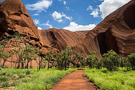
Mutitjulu is an Aboriginal Australian community in the Northern Territory of Australia located at the eastern end of Uluṟu (also known as Ayers Rock). It is named after a knee-shaped water-filled rock hole at the base of Uluṟu, and is located in the Uluṟu-Kata Tjuṯa National Park. Its people are traditional owners and joint managers of the park with Parks Australia. At the 2011 census, Mutitjulu had a population of 296, of which 218 (71.2%) were Aboriginal.[1]
The majority of the Anangu (people) are Pitjantjatjara but there are also associated Yankunytjatjara, Luritja, and Ngaanyatjarra people with the languages spoken being Pitjantjatjara, Luritja, and Yankunytjatjara. Arrernte people also have a traditional relationship with Uluṟu.
- ^ a b Australian Bureau of Statistics (31 October 2012). "Mutitjulu (State Suburb)". 2011 Census QuickStats. Retrieved 17 September 2012.
- ^ "Yulara Postcode". postcode-finders.com.au. Retrieved 17 June 2019.
- ^ "Division of Namatjira". Northern Territory Electoral Commission. Retrieved 16 June 2019.
- ^ "Federal electoral division of Lingiari". Australian Electoral Commission. Retrieved 16 June 2019.
