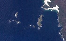
 A Landsat image of the Mutton Bird Islands Group; the Mutton Bird Island is the largest island that is located closest to the coast. | |
Location off the south western coast of Tasmania | |
| Geography | |
|---|---|
| Location | South western Tasmania |
| Coordinates | 43°25′12″S 145°57′58″E / 43.42000°S 145.96611°E |
| Archipelago | Mutton Bird Islands Group |
| Adjacent to | Southern Ocean |
| Area | 44 ha (110 acres)[1] |
| Highest elevation | 40 m (130 ft) |
| Administration | |
Australia | |
| State | Tasmania |
| Region | South West |
| Demographics | |
| Population | Unpopulated |
Mutton Bird Island is an irregularly shaped unpopulated island located close to the south-western coast of Tasmania, Australia. Situated some 2 kilometres (1.2 mi) south of where the mouth of Port Davey meets the Southern Ocean, the 44-hectare (110-acre) is the largest of the eight islands that comprise the Mutton Bird Islands Group. The Mutton Bird Island is part of the Southwest National Park and the Tasmanian Wilderness World Heritage Site.[1][2]
The highest point of Mutton Bird Island is 40 metres (130 ft) above sea level.
- ^ a b "Small Southern Islands Conservation Management Statement 2002" (PDF). Tasmania Parks and Wildlife Service. 2002. p. 30. Archived from the original (PDF) on 22 August 2006. Retrieved 20 July 2006.
- ^ Brothers, Nigel; Pemberton, David; Pryor, Helen; Halley, Vanessa (2001). Tasmania's Offshore Islands: seabirds and other natural features. Hobart: Tasmanian Museum and Art Gallery. ISBN 0-7246-4816-X.
