Mystras
Μυστράς | |
|---|---|
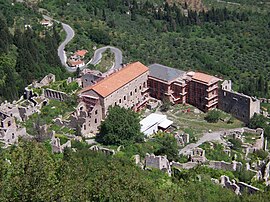
 Despot's Palace (2008) | |
| Coordinates: 37°4′N 22°23′E / 37.067°N 22.383°E | |
| Country | Greece |
| Administrative region | Peloponnese |
| Regional unit | Laconia |
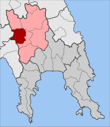
| Municipality | Sparta |
| Area | |
| • Municipal unit | 131.9 km2 (50.9 sq mi) |
| Elevation | 310 m (1,020 ft) |
| Population (2021)[1] | |
| • Municipal unit | 4,238 |
| • Municipal unit density | 32/km2 (83/sq mi) |
| • Community | 724 |
| Time zone | UTC+2 (EET) |
| • Summer (DST) | UTC+3 (EEST) |
| Postal code | 231 00 |
| Area code(s) | 27310 |
| Vehicle registration | ΑΚ |
| Official name | Archaeological Site of Mystras |
| Criteria | Cultural: ii, iii, iv |
| Reference | 511 |
| Inscription | 1989 (13th Session) |
| Area | 54.43 ha |
| Buffer zone | 1,202.52 ha |
Mystras or Mistras (Greek: Μυστρᾶς/Μιστρᾶς),[2] also known in the Chronicle of the Morea as Myzethras or Myzithras (Μυζηθρᾶς), is a fortified town and a former municipality in Laconia, Peloponnese, Greece. Situated on Mt. Taygetus, above ancient Sparta, and below a Frankish castle,[3] it served as the capital of the Byzantine Despotate of the Morea in the 14th and 15th centuries, experiencing a period of prosperity and cultural flowering during the Palaeologan Renaissance, including the teachings of Gemistos Plethon.[2] The city also attracted artists and architects of the highest quality.[2]
Mystras remained inhabited throughout the Ottoman period, when Western travellers mistook it for ancient Sparta. In the 1830s, it was abandoned and the new town of Sparta was built, approximately eight kilometres to the east. Since the 2011 local government reform it is part of the Sparta municipality.[4] As an exceptionally well-preserved example of a Byzantine city and because of its testimony to the development of Late Byzantine and Post-byzantine art, Mystras was inscribed on the UNESCO World Heritage List in 1989.[5]
- ^ "Αποτελέσματα Απογραφής Πληθυσμού - Κατοικιών 2021, Μόνιμος Πληθυσμός κατά οικισμό" [Results of the 2021 Population - Housing Census, Permanent population by settlement] (in Greek). Hellenic Statistical Authority. 29 March 2024.
- ^ a b c Gregory & Ševčenko 1991, p. 1382.
- ^ Ousterhout, Robert (2021). "Late Byzantine Secular Architecture". In Freeman, Evan (ed.). A Smarthistory Guide to Byzantine Art. Smarthistory.
- ^ "ΦΕΚ B 1292/2010, Kallikratis reform municipalities" (in Greek). Government Gazette.
- ^ "Archeological Site of Mystras". UNESCO World Heritage Convention. United Nations Educational Scientific and Cultural Organization. Retrieved 19 November 2021.

