| Nacimiento River Spanish: Río Nacimiento | |
|---|---|
 The river downstream of Nacimiento Dam | |
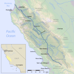
 Map of the Salinas River watershed, including the Nacimiento River | |
| Location | |
| Country | United States |
| State | California |
| Physical characteristics | |
| Source | Unnamed spring |
| • location | Santa Lucia Mountains, San Luis Obispo County |
| • coordinates | 36°01′55″N 121°28′21″W / 36.03194°N 121.47250°W[1] |
| • elevation | 3,280 ft (1,000 m) |
| Mouth | Salinas River |
• location | Camp Roberts, Monterey County |
• coordinates | 35°49′57″N 120°45′30″W / 35.83250°N 120.75833°W[1] |
• elevation | 584 ft (178 m) |
| Length | 64.8 mi (104.3 km) |
| Basin size | 350 sq mi (910 km2) |
| Discharge | |
| • location | below Nacimiento Dam[2] |
| • average | 272 cu ft/s (7.7 m3/s)[2] |
| • minimum | 0 cu ft/s (0 m3/s) |
| • maximum | 7,340 cu ft/s (208 m3/s) |
| Basin features | |
| Tributaries | |
| • right | Los Burros Creek, Las Tablas Creek |
The Nacimiento River (Spanish: Río Nacimiento) is a 64.8-mile-long (104.3 km)[3] river in southern Monterey County and northern San Luis Obispo County, California. A large portion of the river's run is on military reservations. The river's upper reaches are inside Fort Hunter Liggett, Lake Nacimiento is in the middle and the lower reaches are inside Camp Roberts. It is the largest tributary of the Salinas River in terms of streamflow.[4]
- ^ a b "Nacimiento River". Geographic Names Information System. United States Geological Survey, United States Department of the Interior. 1981-01-19. Retrieved 2011-05-03.
- ^ a b "USGS Gage #11149400 on the Nacimiento River below Nacimiento Dam, near Bradley, CA" (PDF). National Water Information System. U.S. Geological Survey. 2009. Retrieved 2011-05-03.
- ^ U.S. Geological Survey. National Hydrography Dataset high-resolution flowline data. The National Map, accessed March 15, 2011
- ^ Cite error: The named reference
CEMARwas invoked but never defined (see the help page).