Nakatonbetsu
中頓別町 | |
|---|---|
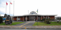
 Nakatonbetsu town hall | |
 Location of Nakatonbetsu in Hokkaido (Sōya Subprefecture) | |
 | |
| Coordinates: 44°58′11″N 142°17′12″E / 44.96972°N 142.28667°E | |
| Country | Japan |
| Region | Hokkaido |
| Prefecture | Hokkaido (Sōya Subprefecture) |
| District | Esashi |
| Area | |
| • Total | 398.51 km2 (153.87 sq mi) |
| Population (June 30, 2024) | |
| • Total | 1,496 |
| • Density | 3.8/km2 (9.7/sq mi) |
| Time zone | UTC+09:00 (JST) |
| Climate | Dfb |
| Website | Official website |
| Symbols | |
| Flower | Kurile Cherry |
| Tree | Sakhalin Spruce |


Nakatonbetsu (中頓別町, Nakatonbetsu-chō) is a town located in Sōya Subprefecture, Hokkaido, Japan.[1] As of 1 July 2024[update], the town had an estimated population of 1,496 in 834 households, and a population density of 8.1 people per km2.[2] The total area of the town is 398.51 km2 (153.87 sq mi).
- ^ Cite error: The named reference
nwas invoked but never defined (see the help page). - ^ "Nakatonbetsu Town official statistics" (in Japanese). Japan.


