Nakhon Nayok
นครนายก | |
|---|---|
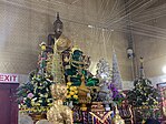
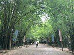
(clockwise from upper-left): Wat Udom Thani, Luang Pho Pak Daeng Buddha at Wat Phrammani, Bamboo Forest of Wat Chulaphonwanaram, Buddharupa Shrine of Srinakharinwirot University’s Ongkharak Campus, Khun Dan Prakan Chon Dam | |
| Motto(s): นครนายก เมืองในฝันที่ใกล้กรุง ภูเขางาม น้ำตกสวย รวยธรรมชาติ ปราศจากมลพิษ ("Nakhon Nayok. City of dreams near the capital. Beautiful mountains. Gorgeous waterfalls. Rich in nature. Free of pollution.") | |
 Map of Thailand highlighting Nakhon Nayok province | |
| Country | Thailand |
| Capital | Nakhon Nayok City |
| Government | |
| • Governor | Amphon Angkapakornkun (since October 2020) |
| Area | |
| • Total | 2,122 km2 (819 sq mi) |
| • Rank | Ranked 67th |
| Population (2018)[2] | |
| • Total | 260,093 |
| • Rank | Ranked 73rd |
| • Density | 123/km2 (320/sq mi) |
| • Rank | Ranked 39th |
| Human Achievement Index | |
| • HAI (2022) | 0.6509 "somewhat high" Ranked 25th |
| GDP | |
| • Total | baht 27 billion (US$1.0 billion) (2019) |
| Time zone | UTC+7 (ICT) |
| Postal code | 26xxx |
| Calling code | 037 |
| ISO 3166 code | TH-26 |
| Website | ww2 |
Nakhon Nayok (Thai: นครนายก, pronounced [ná(ʔ).kʰɔ̄ːn nāː.jók]) is one of the central provinces (changwat) of Thailand, established by the Act Establishing Changwat Samut Prakan, Changwat Nonthaburi, Changwat Samut Sakhon, and Changwat Nakhon Nayok, Buddhist Era 2489 (1946), which came into force on 9 May 1946.
Neighboring provinces are (from north clockwise) Saraburi, Nakhon Ratchasima, Prachinburi, Chachoengsao, and Pathum Thani. Nakhon Nayok is known for waterfalls and fruit varieties.[citation needed]
Nakon Nayok is a nearby province to Bangkok and has various tourist attractions. Khao Yai National Park, Thailands oldest national park is in partly in Nakhon Nayok province and attracts many tourists.[5] Khun Dan Prakarn Chon Dam is another tourist attraction 2 hours outside of Bangkok in Nakhon Nayok.[6]
- ^ Advancing Human Development through the ASEAN Community, Thailand Human Development Report 2014, table 0:Basic Data (PDF) (Report). United Nations Development Programme (UNDP) Thailand. pp. 134–135. ISBN 978-974-680-368-7. Retrieved 17 January 2016, Data has been supplied by Land Development Department, Ministry of Agriculture and Cooperatives, at Wayback Machine.
{{cite report}}: CS1 maint: postscript (link)[dead link] - ^ "ร่ยงานสถิติจำนวนประชากรและบ้านประจำปี พ.ศ.2561" [Statistics, population and house statistics for the year 2018]. Registration Office Department of the Interior, Ministry of the Interior. stat.bora.dopa.go.th (in Thai). 31 December 2018. Archived from the original on 2 April 2019. Retrieved 20 June 2019.
- ^ "ข้อมูลสถิติดัชนีความก้าวหน้าของคน ปี 2565 (PDF)" [Human Achievement Index Databook year 2022 (PDF)]. Office of the National Economic and Social Development Council (NESDC) (in Thai). Retrieved 12 March 2024, page 31
{{cite web}}: CS1 maint: postscript (link) - ^ "Gross Regional and Provincial Product, 2019 Edition". <>. Office of the National Economic and Social Development Council (NESDC). July 2019. ISSN 1686-0799. Retrieved 22 January 2020.
- ^ Round, Philip D.; Gale, George A. (2007-10-17). "Changes in the Status of Lophura Pheasants in Khao Yai National Park, Thailand: A Response to Warming Climate?". Biotropica. 40 (2): 225–230. doi:10.1111/j.1744-7429.2007.00363.x. ISSN 0006-3606.
- ^ Jetsadaareewong, Suphattra (2017). "White Water Rafting Management at Khun Dan Prakan Chon Dam, Nakornnayok Province". SSRN Electronic Journal. doi:10.2139/ssrn.3076749. ISSN 1556-5068.


